HENGE MONUMENTS
c. 3000 BC – c. 1500 BC
A basic henge is simply a, roughly, circular space, enclosed by a ditch and bank earthwork, with an entrance, or entrances, leading to the centre. As a rule (there are, of course, exceptions), the bank is built up on the outside of the ditch – an arrangement usually regarded as being unsuitable for defensive purposes. Most henges contained various types of feature – for instance, arrangements of stones, timbers or pits.
It is generally thought that they were ceremonial centres, where people would gather together to take part in religious rituals and other communal activities. Stone circles (where a space is enclosed by standing stones), presumably fulfilling a similar role, were also constructed. Some henges combine a ditch and bank with a stone circle – including the two most famous (and magnificent), Stonehenge and Avebury, both in Wiltshire.
The archaeological term ‘henge’ is actually a back-formation from the name Stonehenge (originating in Anglo-Saxon times – having the meaning ‘hanging stones’), but Stonehenge, which represents the culmination of stone circle engineering, is not at all a typical henge.
STONEHENGE
There are four wonders which may be seen in England… The second is at Stonehenge [Stanenges], where stones of remarkable size are raised up like gates, in such a way that gates seem to be placed on top of gates. And no one can work out how the stones were so skilfully lifted up to such a height or why they were erected there.Henry of Huntingdon, Historia Anglorum (I, 7), written c.1130,
translated by Diana Greenway[*]
Stonehenge’s first chronicler, Henry of Huntingdon, mused on ‘the how’ and ‘the why’ of its construction, and nine centuries later archaeologists are still trying to provide satisfactory answers to those two basic questions. Considerable progress has, however, been made in unravelling Stonehenge’s history, and, thanks to Radiocarbon dating, answering a third important question: ‘the when’.
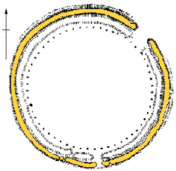
STAGE 1, c.3000 BC. Work on Stonehenge began in about 3000 BC, with the digging of the ditch and bank – enclosing an area roughly 92 metres in diameter[*]. Uncharacteristically for a henge, the bank was on the inside of the ditch. (There was also a low outer bank, now severely eroded by agriculture.) When new, the chalk bedrock of Salisbury Plain would have ensured the earthwork stood out boldly in the landscape. There were two entrance causeways – the main, larger, one to the north-east and a smaller one to the south. There were probably arrangements of timber posts within the henge and at the main entrance[*]. On the inner side of the earthwork circle there may have been a circuit of fifty-six timber posts or standing stones. These hypothetical posts or, more controversially, stones, would have stood in the filled-in pits known as Aubrey Holes[*]. The most popular theory in recent years has been that they held timber posts, but archaeologists of the Stonehenge Riverside Project (SRP) excavated one in August 2008, and the condition of its chalk base led them to believe that it had once supported a standing stone.[*] Researching archive material revealed that similar crushing of the chalk had been observed in other Aubrey Holes during previous excavations.
henge01
The SRP have gone further, proposing that the Aubrey Holes originally contained ‘bluestones’, which have generally been seen as much later arrivals at Stonehenge.[*] Most of the thirty-four Aubrey Holes that have so far been excavated contained cremation burials.
henge02
The site seems to have stayed in this form for about half a millennium. The ditch was neglected, and slowly filled with sediment. In about 2500 BC, however, Stonehenge entered a period of development during which stones were arranged and rearranged, to eventually produce the monument whose impressive wreckage remains today.
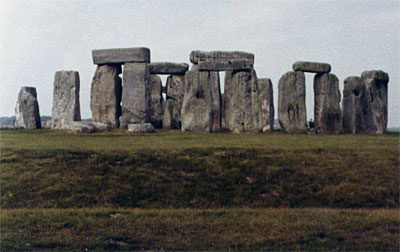
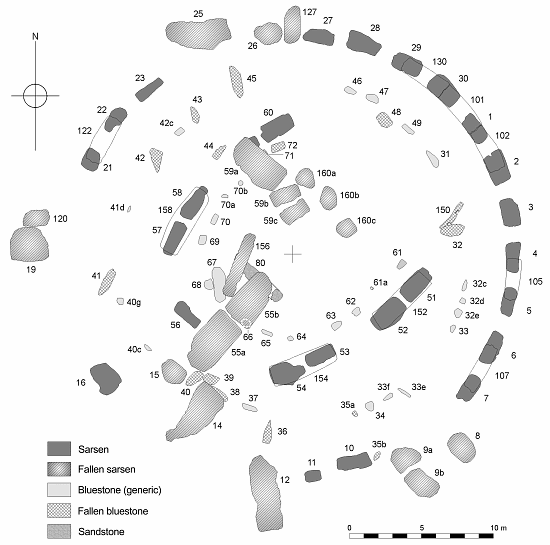
STAGE 2, c.2500 BC. The stone settings built at the centre of Stonehenge fall into two categories: those made from bluestones, and those made from sarsens. Sarsens are naturally occurring sandstone slabs, and recent research suggests that the majority of those used at Stonehenge were probably sourced from the vicinity of West Woods, 15 or so miles to the north[*]. In about 2500 BC, a circle (30 metres in diameter) of thirty sarsen uprights (standing approximately 4 metres above ground level), topped-off by a continuous circuit of sarsen lintels, was erected around a horseshoe arrangement (the open end pointing in a north-easterly direction) of five, massive, sarsen ‘trilithons’[*]. Construction of this megalithic masterpiece would have taken an enormous number of man-hours. Once the, not inconsiderable, task of dragging the rough sarsens to the site had been accomplished, these, extremely hard, rocks were shaped and smoothed, and had joints sculpted into them using the most rudimentary of stone tools[*]. Having levered the uprights vertical, the lintels then had to be raised (up to 7 metres above the ground), and dropped into position[*].
The first appearance of bluestones at the centre of the henge – indeed, their first definite appearance anywhere on site – was in a concentric double arc setting. The evidence for this placement is provided by the, so-called, Q and R Holes, which lie between the sarsen circle and trilithon horseshoe settings.
henge03
There are no reliable radiocarbon dates for the double arc, but Richard Atkinson’s excavations, in the mid-1950s, indicated that it was the earliest stone setting in the henge’s centre. As a result, it has usually been placed a short while before the arrival on the scene, in about 2500 BC, of the massive sarsens – the theory being that this rather modest bluestone arrangement was quickly abandoned and removed, to make way for a much more ambitious scheme.[*] The SRP has, however, questioned the supposed stratigraphic relationship between the bluestone arcs and the sarsens, and suggested that the settings were contemporaries – that the sarsen horseshoe, sarsen circle and bluestone arcs were all part of a single design.
henge04
The bluestones underwent subsequent rearrangement (of which more later), and it would seem that there were about eighty of them in total – the remains of about forty-three survive (some are just buried stumps). As already mentioned, the SRP has suggested that there were bluestones planted in the fifty-six Aubrey Holes centuries before their first appearance at the henge’s centre. In 2009 the SRP excavated a newly discovered feature, just over a mile to the south-east of Stonehenge, adjacent to the river Avon. It had been the site of a small stone circle – about 10 metres in diameter, with an estimated twenty-five standing stones – at about the same time as Stonehenge’s beginnings.[*] The SRP have proposed that these stones were also bluestones. They suggest that the stones from both the Aubrey Holes and this newly found monument (which has been dubbed Bluestonehenge) were recycled in the centre of Stonehenge.[*]
The bluestones are of a variety of rock-types, and most of them evidently originated in and around the Preseli Hills of south-west Wales[*]. To transport dozens of two-ton stones some 150, as the crow flies, miles, over land and water, using muscle power alone, is an extraordinary achievement – in fact too extraordinary for some authorities to accept as credible. Evidence for the alternative theory – that they were transported to the vicinity of Stonehenge by a glacier (which would account for the motley mix of rock-types) – is though, at the moment, not overwhelming, and the debate continues.
henge05
… detailed investigations of the features at the site by the three authors of this paper suggest that there is no sign of human quarrying activity – either related to the removal of monoliths intended for transport to Stonehenge, or for any other purpose…
It is suggested, on the basis of careful examinations of this site, that certain of the “man made features” described have been created by the archaeologists themselves through a process of selective sediment and clast removal. An expectation or conviction that “engineering features” would be found has perhaps led to the unconscious fashioning of archaeological artifices.[*]In August 2018 a paper submitted by a group of researchers, including Mike Parker Pearson, was published in Scientific Reports. The Abstract states:
Cremated human remains from Stonehenge provide direct evidence on the life of those few select individuals buried at this iconic Neolithic monument… New developments in strontium isotopic analysis of cremated bone reveal that at least 10 of the 25 cremated individuals analysed did not spend their lives on the Wessex chalk on which the monument is found. Combined with the archaeological evidence, we suggest that their most plausible origin lies in west Wales, the source of the bluestones erected in the early stage of the monument’s construction. These results emphasise the importance of inter-regional connections involving the movement of both materials and people in the construction and use of Stonehenge.[*]In February 2021, Mike Parker Pearson and his archaeological team published a paper (Antiquity Vol. 95, Issue 379) proposing that some of Stonehenge’s bluestones had stood in a stone circle at Waun Mawn, in the Preseli Hills, before being uprooted and moved to Salisbury Plain[*]. Such few stones that remain of the erstwhile monument at Waun Mawn are of ‘unspotted dolerite’, as is a flake from one of the stones that has been removed from the site. In the paper, the stone to which this flake belonged is said to have left an “unusual pentagonal imprint” on the bottom of its stonehole, and this is said to match the base cross-section of an unspotted dolerite which still stands at Stonehenge (Stone 62). The authors conclude:
… it seems that Stonehenge stage one was built – partly or wholly – by Neolithic migrants from Wales, who brought their monument or monuments as a physical manifestation of their ancestral identities to be re-created in similar form on Salisbury Plain …The story presented by Parker Pearson et al. – which invoked a nonsensical fairy-tale (called a “legend” in the paper) told by Geoffrey of Monmouth, about Merlin building Stonehenge with the stones of a giants’ stone circle brought from Ireland: perhaps it “contains a grain of truth” – garnered much publicity. The BBC made a documentary, Stonehenge: The Lost Circle Revealed – it was said that the base of Stone 62 and the unusual stonehole imprint “fitted like a key in a lock”, and Mike Parker Pearson referred to Stonehenge as “a second-hand monument”. Somewhat embarrassingly, subsequent geological analysis showed that the stone used at Waun Mawn did not match Stonehenge Stone 62. The stones at Waun Mawn were probably sourced locally, from Cerrig Lladron about 1½ miles to its southwest. The probable source of Stone 62 has been identified as Garn Ddu Fach, an outcrop about 4 miles to the east-southeast of Waun Mawn.[*] In 1924, the right mandible of a cow (the beast was probably female) was excavated from the bottom of the ditch on the east side of the southern entrance to Stonehenge. This unprepossessing object would appear to have been ‘special’, since its radiocarbon date, albeit imprecise, suggests it was already old when it was deposited in the ditch at the time of Stonehenge’s very beginnings. In August 2025 a paper was published in the Journal of Archaeological Science (Vol. 180) concerning an isotope analysis conducted on the enamel of a molar from the mandible[*]. The paper itself is rather technical, but its publication was apparently accompanied by interviews with the researchers, which were widely and variously reported in the media. The paper’s main author, Jane Evans (British Geological Survey), is quoted, in The Guardian, saying:
… very early in its life it [the cow] incorporated lead into its skeleton and that lead was from old Palaeozoic rocks, older than about 400m years old. Those types of rocks crop up primarily in Britain in Wales, which is the nearest supply, and also in the Lake District and Scotland… Wales is the closest area from which you get those kind of lead compositions. That suggests this animal, found in Wiltshire, didn’t start life in that kind of area. It must have been grazing at some time on older rocks, and the obvious conclusion, given it’s Stonehenge, is that Wales is the probable origin of the cow’s early life.Whilst on the BBC News website appears the quote:
You can tell that the animal has been grazing on the Palaeozoic rock, typical of those found in Wales, particularly in and around where bluestones are found.Professor Evans makes reference (not made in the paper itself) to a previous study:
There’s been no evidence that cattle were used as beasts of burden in the Neolithic, but that changed in 2018 when there was a paper that showed that oxen had structures in their feet that were typical of animals that were pulling additional weight and working of [sic] beasts of burden.[*]One of Prof. Evans’ co-authors, the ubiquitous Mike Parker Pearson, sums up:
This is yet more fascinating evidence for Stonehenge’s link with south-west Wales, where its bluestones come from. It raises the tantalising possibility that cattle helped to haul the stones.British Geological Survey News
Professors Timothy Darvill and Geoffrey Wainwright consider the bluestones to be Stonehenge’s raison d'être. They believe the stones were thought to have healing properties, and that Stonehenge was “a prehistoric Lourdes” – a place of pilgrimage, to where people would travel in the hope of being cured.[*]
There were four isolated sarsens, known as the Station Stones, erected, just inside of the bank, on the corner points of a remarkably accurate rectangle framing the central settings.
henge06
In about 2450/2400 BC, the so-called Beaker People arrived in Britain.[*]
STAGE 3, c.2400 BC. Around 2400 BC, the Avenue, a processional route leading to Stonehenge’s main, i.e. north-eastern, entrance, was constructed.
henge07
The henge’s silted-up ditch was re-cut.[*]
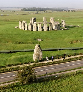
The, now recumbent (and colourfully named), Slaughter Stone is the sole remnant of a megalithic portal into the henge. Standing in the Avenue, but not on the centre-line, about 78 metres distant from the circle centre, is a massive unworked sarsen, called the Heel Stone.
|
Photograph courtesy of Adam Stanford
The Avenue was, until recently, cut by the A344 road. In 2013 the road was closed, and the section adjacent to Stonehenge dug-up and grassed over.
The Heel Stone stands in the foreground. Beyond the tourist walkway is the Slaughter Stone, lying in the entrance to Stonehenge.
© Aerial-Cam/SRP 2008. |
© Aerial-Cam/SRP 2008.
henge08
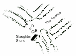
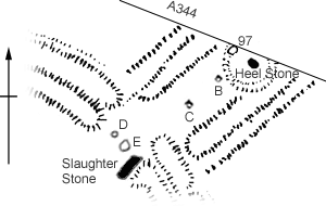 In 1979 a stonehole was found (97) which suggested that, at one time, the Heel Stone had a partner that was, at some stage, removed and a ditch dug around the, now solitary, Heel Stone. Rodney Castleden comments:
I can offer no explanation at all for the removal of stone 97: as far as I know, no one has yet offered a plausible explanation. The pair of Heel Stones made a perfect ritual doorway for the midsummer sun …[*]There is, though, a plausible explanation (one favoured by the SRP). Evidently Stonehole 97 was cut into the infill of an earlier, larger, hole. It may well be that this was the Heel Stone’s natural resting place. It was first erected into Stonehole 97, but was later moved into its present position. Aubrey Burl suggests that the Heel Stone was first erected long before the henge was dug. He argues that it was one in a series of stones marking the line of an ancient trackway, and was later integrated into the monument.[*] In 1620, King James I instructed the architect Inigo Jones to investigate Stonehenge. The result was a book, Stone-Heng Restored, in which Jones presents his vision of how the monument originally looked (below). He gives the Slaughter Stone a partner – but he also shows three entrances and six trilithons.
 It seems, however, that, though he believed there were three entrances, Jones’ notion of how they looked was based on the observation of only one. After his death, his protégé John Webb wrote (Vindication of Stone-Heng Restored, 1665) that: “he [Jones] hath described in his Draught Two Stones … these were the two parallel Stones that stood upon the inside of the Trench, at the Entrance from the North-East”.
In John Aubrey’s plan, The Ichonographie of Stoneheng as it remaines this present yeare 1666 (below), the Slaughter Stone and its colleague are both shown, seemingly still standing. Further, Jones envisaged an opposing pair of uprights on the outside of the ditch, and Aubrey records one of them, again seemingly still standing, on his plan.
It seems, however, that, though he believed there were three entrances, Jones’ notion of how they looked was based on the observation of only one. After his death, his protégé John Webb wrote (Vindication of Stone-Heng Restored, 1665) that: “he [Jones] hath described in his Draught Two Stones … these were the two parallel Stones that stood upon the inside of the Trench, at the Entrance from the North-East”.
In John Aubrey’s plan, The Ichonographie of Stoneheng as it remaines this present yeare 1666 (below), the Slaughter Stone and its colleague are both shown, seemingly still standing. Further, Jones envisaged an opposing pair of uprights on the outside of the ditch, and Aubrey records one of them, again seemingly still standing, on his plan.
The whole monument is aligned on the axis of the midsummer sunrise and midwinter sunset. The tendency is to assume that it was the midsummer sunrise, as seen looking out from the centre of the stone settings down the Avenue (at the time Stonehenge was built, the sun would have risen just to the west of the Heel Stone), that was the main point of this alignment. It may be, however, that the midwinter sunset (the sun would have set between the uprights of the Great Trilithon), at the opposite end of the axis, was, at least, equally significant.
An arc of four stoneholes may be all that remains of a bluestone circle, built within the horseshoe of sarsen trilithons.
STAGE 4, c.2200 BC. Round about 2200 BC, bluestones were arranged in a circle, running inside the sarsen circle. According to the SRP’s proposed sequence, the bluestones of this new circle had, until this time, stood in the Q and R Holes (the previous notion was that they had been removed from the site when the sarsens were installed, only to be brought back at this time). The small bluestone circle inside the sarsen trilithon horseshoe, assuming there was such a structure, was apparently restyled into an oval.[*] No actual stones are now present at the north-eastern end of the oval (though there are stoneholes), and it has been supposed they were removed in prehistoric times in order to produce a bluestone horseshoe setting that echoed the sarsen trilithon setting. It is perhaps the most controversial proposal of the SRP that this bluestone horseshoe did not exist. Based on the observations of Timothy Darvill and Geoffrey Wainwright, made during their 2008 excavation, it is suggested that the missing stones were robbed in Roman, and later, times, and that the prehistoric setting was always an oval.
Placed within the oval/horseshoe, near the south-western end – at the heart of the monument – was the, so-called, Altar Stone: a five-metre-long, six-ton, dressed, greenish sandstone block. The Altar Stone (Stone 80) is classed as a bluestone, and until recently the supposition had been that, like other bluestones, it originated in Wales, though finding a more precise location had proved problematic. New (in 2024) research indicates that the source of the Altar Stone is, in fact, the Orcadian Basin of northeast Scotland – more than 450 miles from Stonehenge. Furthermore, it is not thought possible that the stone was transported to Stonehenge by a glacier. Assuming this research stands the test of time, then the conclusion would have to be that people moved the Altar Stone the enormous distance from Scotland to Wiltshire.[*] Anyway, the Altar Stone is recumbent today, and broken in two, pinned down by stones from the collapsed Great Trilithon. [Plan]
henge09
The present arrangement of Horseshoe and Circle must have been the product of an intentional remodelling of the monument… it is clear that at some stage the Horseshoe and Circle were intended to be the major Bluestone setting of the interior …But in Stonehenge: Exploring the Greatest Stone Age Mystery (2012), Mike Parker Pearson declares:Chapter 7 (p.231)
Out goes the bluestone horseshoe – there is no archaeological justification for regarding it as a separate prehistoric entity: it is more probably simply the degraded remains of the bluestone oval.The distinguished archaeologist Francis Pryor (Stonehenge, The Story of an Ancient Landscape, 2016) is, however, sticking to the old interpretation:Chapter 20 (p.311)
Somewhat later in Stage 4 the bluestones at the northeastern end of the oval were removed, to leave a U-shaped setting that echoed the much larger Trilithon Horseshoe immediately outside and above it.At any rate, whilst the stones employed in the oval/horseshoe are shaped and polished dolerite, the stones in the circle are a motley collection of mostly unworked stones. Aubrey Burl opines:Chapter 7
The circle bluestones, like leftovers, were hastily and carelessly set up as though they had been no more than a method of using up the remaining stones.Whilst Rodney Castleden says they:A Brief History of Stonehenge (2007), Chapter 9 (p.245)
… skulk among the sarsens, like dwarfs among giants, in an irregular ring …The Making of Stonehenge (1993), Chapter 7 (pp.176–7).
STAGE 5, c.1600 BC. About nine hundred years after the sarsens had been raised, two, inaccurate, concentric circles of pits (the Y and Z Holes) were dug around the outside of the circle. They never received stones – they were left open, and gradually silted-up. This apparently half-hearted project, undertaken around 1600 BC, seems to mark the end of Stonehenge’s usefulness.[*]
Built to inspire awe, Stonehenge was clearly a sacred place where rituals took place. Beyond that generalization, however, its purpose and meaning have long been the subject of speculation. The SRP has found evidence supporting Mike Parker Pearson’s theory that Stonehenge was but one component of a larger ritual complex. Durrington Walls, Britain’s largest henge (around 480 metres in diameter), and its smaller (around 85 metres in diameter) companion, Woodhenge, lie in a little valley less than two miles to the north-east of Stonehenge. In 2005, a metalled roadway connecting the Southern Circle of Durrington Walls – a 40 metre diameter timber monument within the henge – to the river Avon was discovered.
henge10

Whereas Stonehenge and the Avenue were aligned on the axis of the midsummer sunrise and midwinter sunset, the Southern Circle and roadway (Durrington Avenue) were aligned on the axis of the midwinter sunrise and midsummer sunset. The timber structure of the Southern Circle was linked, via Durrington Avenue, the river Avon and Stonehenge Avenue, to the stone structure of Stonehenge. Professor Parker Pearson believes that the, short-lived, timber structure represented the land of the living, whilst the permanent stones of Stonehenge represented the realm of the ancestors. Symbolic journeys between to the worlds of the living and the dead could be made via the monuments’ ceremonial Avenues and the river.
Nobody ever lived at Stonehenge, but at Durrington Walls the remains of houses that were in use at the time the central sarsen settings were erected at Stonehenge, and that pre-date the construction of the henge of Durrington Walls, have been found.
The Durrington Avenue and Southern Circle were the main components of a ceremonial complex, later encircled by the henge bank and ditch, which formed the focus of a very large settlement whose house floors have been well preserved beneath colluvium.[*]… The discovery of houses within, underneath and outside Durrington Walls suggests that a large area of the valley in which the henge lies was probably covered in dwellings… It is likely that these dwellings were lived in by the builders of the Southern Circle and Stonehenge, and latterly the Durrington Walls and Woodhenge henges.Stonehenge Riverside Project, Summary Interim Report on the 2006 Season
Furthermore, the nature of the debris associated with the settlement, indicates that great midwinter feasts took place there[*].
Professor Parker Pearson is persuasive – he may well be right – but, unfortunately, we can never know with certainty. As Samuel Pepys, having found the stones of Stonehenge “as prodigious as any tales I ever heard of them”, confided to his diary on the 11th of June 1668: “God knows what their use was!”
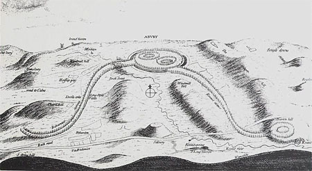
AVEBURY
This old monument does as much exceed in greatness the so renowned Stoneheng [sic], as a Cathedral doeth a parish Church …John Aubrey (1626–97), Monumenta Britannica[*]
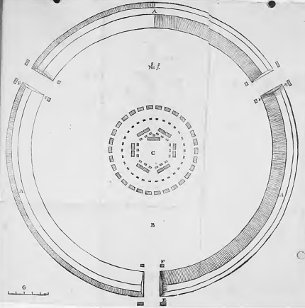
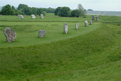
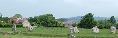
Avebury is about 17 miles north of Stonehenge. Even today its earthwork, enclosing an area roughly 350 metres in diameter, is impressive. [Plan] When built the bank would have been something like 27 metres wide at the base and 6 metres high. The ditch was 9 metres deep and some 14 metres wide at the top, tapering to less than half that at the bottom.[*] There were entrance causeways at the north, south, east and west. These breaks in the earthwork were, millennia later, adapted to carry the roads serving the village of Avebury, which inhabits the henge.
henge11
From the evidence available, it can be argued that early medieval settlement began immediately to the southwest of the henge monument, probably during the 6th century, and most likely comprised a single farmstead. By the early 9th century the settlement had moved northwards and eastwards, up to the west entrance of the henge itself… With the exception of property boundaries, settlement lay largely without the henge until the post-medieval period …Freely available online.
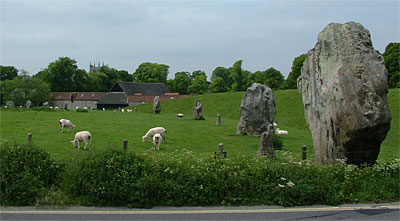
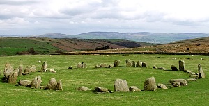
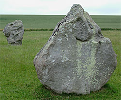
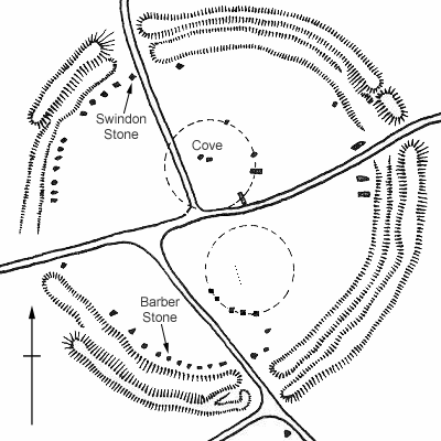
Some of the massive (in the region of 60 ton) stones that acted as portals can still be seen. Both remain at the southern entrance. One, the Swindon Stone, stands at the northern entrance. According to, antiquarian, William Stukeley (1687–1765), the Swindon Stone’s partner (a stone “of a most enormous bulk”) fell down, and broke, in 1722: “we saw three wooden wedges driven into it, in order to break it in pieces.” One fallen stone marks the eastern entrance. Nothing remains at the western entrance. The portal stones are components of a ring, originally comprising about a hundred standing stones, set around the perimeter of the enclosed area. Thirty stones of this Outer Circle can still be seen, of which three are fallen. There were two inner stone circles, each roughly 100 metres in diameter. All the stones at Avebury are sarsens – found locally, on the Marlborough Downs, a couple of miles to the east. They have been left in their natural state – not smoothed or worked to shape, as happened at Stonehenge. It seems, though, that, in the circles, the stones were set so that their, naturally, smoothest side faced inwards.[*] The Southern Inner Circle comprised about thirty stones, set around a central Obelisk. Today, five stones from this circle stand in an impressive arc. The Obelisk is no more. It was, though, sketched by William Stukeley in 1723[*]. To the west of the Obelisk (its position is now marked by a concrete plinth), but still within the Southern Inner Circle, can be seen six smallish stones, standing in a line running roughly north-south – remnants of the so-called Z Feature[*]. Outside the Southern Inner Circle, to the south, stood the Ring Stone. All that remains is a stump, but according to William Stukeley the stone (“not of great bulk”) had “a hole wrought in it”. Only four stones from the Northern Inner Circle can still be seen, two of which are fallen. It is possible that this circle wasn’t actually a circle at all. It may have been a horseshoe – open on the south. Either way, at its centre was the Cove – three stones set in a U-shaped arrangement – which opened towards the north-east (in the general direction of midsummer sunrise).[*] Two of the three stones still exist[*]. In 2003, ahead of engineering work to prevent them collapsing, a limited excavation of the Cove stones’ footings was undertaken. The mighty back-stone, which projects almost 4½ metres above ground, was found to extend more than 2½ metres below ground (the base was not reached) – it could weigh 100 tons – and OSL dating indicated that it had been erected in 3120±350 BC.
Avebury’s chronology is not clear. Even if the Cove’s back-stone was erected c.3000 BC, it does not necessarily follow that the Cove as a whole was built at that early date. Radiocarbon assays of antler-picks tend to place the massive henge earthwork in the period 2600 BC–2500 BC.[*] The outer stone circle probably followed soon afterwards. The inner circles could predate the earthwork. Two avenues of standing stones – approaching the western (Beckhampton Avenue) and the southern (West Kennet Avenue) entrances of the henge – are evidently broadly contemporary with the earthwork[*].
Avebury’s stones seem to have remained unmolested until the early-14th century. Then, perhaps because they were offending Christian sensibilities, many were tipped into pits and buried. In 1934, Avebury was bought by a rich archaeologist, Alexander Keiller (of the ‘Dundee Marmalade’ family). His intention was to restore the site to something like its former glory. He cleared away trees, undergrowth and rubbish. He removed fences, old barns, and derelict cottages. Indeed, he wanted to rid the henge of all buildings, and used to have houses demolished as they became vacant. Keiller’s investigations along the western half of the Outer Circle brought to light several buried stones. He re-erected them in their original positions. Where he found a stonehole, but the stone itself was missing, he had the position marked with a concrete plinth. Trapped by one of the buried stones was a human skeleton. It was dated, by coins, to the early-14th century, and was identified as the remains of a barber-surgeon, by virtue of a pair of scissors and a medical-looking probe or lance. It was thought he had been accidentally crushed whilst assisting with the burial of the stone, but a more recent examination of the skeleton seems to indicate that this was not the case.[*] Maybe he was pinned to the ground and died of suffocation, or, rather more sinisterly, maybe he had been murdered and his body buried with the stone[*]. At any rate, the re-erected stone is known as the Barber Stone. Keiller had begun excavating the Southern Inner Circle when his work was interrupted, by the outbreak of the Second World War, in 1939. The National Trust bought Avebury in 1942. When the war ended, Keiller’s poor health prevented him from resuming his excavations, though he continued to live in Avebury Manor until his death, in 1955.
Before the war brought his investigations to a premature end, Alexander Keiller had discovered, in the western half of the Southern Inner Circle, the buried remains of what was called the Z Feature. The stones of this feature (Keiller identified twelve, six of which were intact and were re-erected) had been arranged in a line, running roughly north-south, about thirty metres long, at each end of which the setting turned eastwards.[*] The eastern side of the Southern Inner Circle has not been excavated, but a geophysical survey carried out in 2017 places the Z Feature at the western end of a square setting of stones, with the Obelisk at its centre. Further, Keiller interpreted some linear cuttings in the chalk adjacent to the Obelisk as medieval – the traces of a shed built against the fallen Obelisk. The archaeological team responsible for the 2017 geophysical survey (the Living with Monuments Project), however, believe there is enough evidence to propose that there was once an “early Neolithic house-like structure” at the heart of the Southern Inner Circle.
henge12
This report describes the results of fieldwork carried out as one component of the AHRC-funded Living with Monuments Project that seeks to investigate the earliest structural activity at Avebury through a combination of detailed archival work (both antiquarian; earlier survey; unpublished 1930s excavation records) and targeted geophysical prospection…
… there are grounds for believing that a series of chalk-dug linear features encountered during 1939, and interpreted by Keiller as an unconventional, open-sided medieval ‘lean-to’ constructed against the bulk of the fallen Obelisk megalith (a 7m long sarsen) are in fact of early Neolithic date. This is based on: the absence of medieval pottery from these features; the presence here of a concentration of early Neolithic material; their morphology, where in plan the closest match is with a growing body of excavated early Neolithic houses and mortuary enclosures. Furthermore, the axis of the structure is shared by that of the ‘Z-feature’ stone-holes (stones i-xxii) of the Southern Inner Circle. It is hypothesized that the latter represent a later lithic elaboration of this ‘foundational’ structure.(This paper is freely available online.)
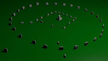 Above, computer model of the Southern Inner Circle released by the Project in 2017. (The Ring Stone is the outlier, bottom-left.)
Surveys, both ancient and modern, have located a number of buried stones in the eastern half of the Outer Circle. Indeed, there exists an almost continuous arc of fifteen stones in the south-eastern quadrant (thirteen buried, two fallen, and one is missing), but there are no current plans to follow Keiller’s example and re-erect them.
The stones which survived, out-of-sight, underground are the lucky ones. John Aubrey (d.1697) says he had heard from a local parson:
… that these mighty stones, as hard as marble, may be broken in what part of them you please without any great trouble: sc. Make a fire on that line of the stone, where you would have it crack; and, after the Stone is well heated, draw over a line with cold water, & immediately give a knock with a Smyth’s sledge, and it will break like the Collets at the Glass house.Monumenta Britannica
By the time William Stukeley visited Avebury (1719–24), the work of stone-breaking was in full swing.
Just before I visited this place, to endeavour at preserving the memory of it, the inhabitants were fallen into the custom of demolishing the stones, chiefly out of covetousness of the little area of ground, each stood on… The custom of thus destroying them is so late, that I could easily trace the obit of every stone; who did it, for what purpose, and when, and by what method, what house or wall was built out of it, and the like.[*]Abury, Temple of the British Druids, with some others, Described (1743),[*] Chapter 3 (pp.15–16)
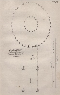
West Kennet Avenue connected Avebury to a stone circle, almost 2 miles to the south, whimsically called the Sanctuary. William Stukeley witnessed the destruction of this latter monument in 1723–4.
henge13
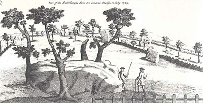
This Overton-hill from time immemorial, the country-people have a high notion of. It was (alas, it was!) a very few years ago crown’d with a most beautiful temple of the Druids. They still call it the sanctuary… It had suffer’d a good deal when I took that prospect of it, with great fidelity, anno 1723, which I give the reader in plate XXI [below].Abury, Temple of the British Druids, with some others, Described (1743), Chapter 7 (p.31)
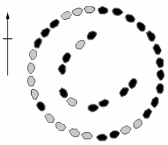
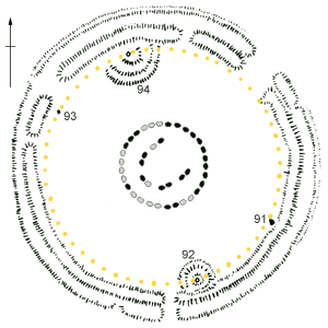
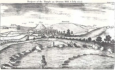 By the end of 1724, all the stones had been removed, and the land ploughed over. The site was found, using Stukeley’s work as a guide, in 1930. When it was excavated, not only were there the holes from the two concentric stone circles sketched by Stukeley (the diameter of the outer circle is about 40 metres), but there were also holes for six concentric rings of timber posts. Interpreting the building sequence of this monument continues to keep archaeologists entertained. It has been suggested that the postholes are the remains of roofed buildings (the same has been said of Woodhenge’s posthole rings), but it is probably fair to say that most archaeologists today are inclined to the view that they held free-standing posts. Possibly the posts had timber lintels, or perhaps they were decorated in the fashion of totem-poles.
John Aubrey recorded West Kennet Avenue on the plan of Avebury he made in 1663, but that was the only avenue of standing stones he recorded.[*] It would seem that Beckhampton Avenue, which connected to Avebury’s western entrance, had been so thoroughly erased that Aubrey failed to notice its faint traces. William Stukeley, though, did; or at least he claimed he did. Stukeley (who was ordained in 1729, becoming a Church of England vicar) became convinced that the religion of the Druids (who had built Avebury) was the antecedent of the doctrine of the Church of England.
henge14
My intent is (besides preserving the memory of these extraordinary monuments, so much to the honour of our country, now in great danger of ruin) to promote, as much as I am able, the knowledge and practice of ancient and true Religion; to revive in the minds of the learned the spirit of Christianity, nearly as old as the Creation, which is now languishing among us; to restore the first and great Idea of the Deity, who has carry’d on the same regular and golden chain of Religion from the beginning to this day; to warm our hearts into that true sense of Religion, which keeps the medium between ignorant superstition and learned free-thinking, between slovenly fanaticism and popish pageantry, between enthusiasm and the rational worship of God, which is no where upon earth done, in my judgment, better than in the Church of England. And seeing a spirit of Scepticism has of late become so fashionable and audacious as to strike at the fundamentals of all revelation, I have endeavoured to trace it back to the fountain of Divinity, whence it flows; and shew that Religion is one system as old as the world, and that is the Christian Religion; that God did not leave the rational part of his creation, like the colony of an ant-hill, with no other guide than instinct, but proportion’d his discoveries to the age of the world, to the learning, wisdom, and experience of it; as a wise parent does now to his children. I shall shew likewise, that our predecessors, the Druids of Britain, tho’ left in the extremest west to the improvement of their own thoughts, yet advanc’d their inquiries, under all disadvantages, to such heights, as should make our moderns asham’d, to wink in the sunshine of learning and religion. And we may with reason conclude, there was somewhat very extraordinary in those principles, which prompted them to such a noble spirit as produced these works, still visible with us, which for grandeur, simplicity and antiquity, exceed any of the European wonders.
He developed the idea that:
The whole temple of Abury may be considered as a picture, and it really is so… When I frequented this place, as I did for some years together, to take an exact account of it, staying a fortnight at a time, I found out the entire work by degrees. The second time I was here, an avenue was a new amusement. The third year another. So that at length I discover’d the mystery of it, properly speaking; which was, that the whole figure represented a snake transmitted thro’ a circle; this is an hieroglyphic or symbol of highest note and antiquity.Abury, a Temple of the British Druids, with some others, Described, Chapter 4 (p.18)
| William Stukeley’s: ‘A Scenographic view of the Druid temple of Abury in north Wiltshire, as in its original.’ |
The Sanctuary, at the end of West Kennet Avenue, formed the serpent’s head, and Beckhampton Avenue formed the tail. Beckhampton Avenue, however, was not clearly visible on the ground, and, since Stukeley did tamper with his earlier findings to make them better fit his theory, it is no wonder that its very existence was doubted.
henge15
… there is evidence of one grave and deliberate falsification which can be traced by means of the assembled Stukeley papers. His published plan of the stone circles at The Sanctuary … shows them as ovals, not true circles. But the 1930 excavations of the site showed them to be in fact accurately circular, and we find that Stukeley’s original field-surveys of the site, which survive, show true circles and minor features completely in accordance with the facts as recovered by excavation. An intermediate link is an original drawing of c.1740 in which the positions of the stones are arranged as ovals in grey wash, but are superimposed on a faint pencil outline showing them as circles, while in one of the original plans an oval outline has been roughly sketched in. It appears that by 1740 the mystic serpent had to be given a more naturalistic head than that afforded by true circles, and the original survey was altered accordingly.William Stukeley: an Eighteenth-Century Antiquary (1950) Chapter 4 (p.129)
Stukeley was vindicated, to some extent anyway, when traces of Beckhampton Avenue were found by archaeologists working around the Longstones in 1999, 2000 and 2003. The Longstones are, today, two standing stones, called Adam and Eve, halfway down Stukeley’s plan of Beckhampton Avenue. However, whilst Stukeley continued Beckhampton Avenue southwards, making it about the same length as West Kennet Avenue, no archaeological evidence was found to indicate that it extended beyond the Longstones.
henge15
This Longstone cove, vulgarly call’d long stones, is properly a cove, as the old Britons call’d ’em, compos’d of three stones, like that most magnificent one we described, in the center of the northern temple at Abury; behind the inn… Mr. Aubry in his manuscript observations publish’d with Mr. Camden’s Britannia, speaks of them by the name Devil’s coits. Three huge stones then standing. It was really a grand and noble work. The stone left standing [i.e. Adam], is 16 feet high, as many broad 3½ thick. The back stone is fallen flat on the ground, of like dimension… The other was carried off by that destroyer Richard Fowler, together with many more, but seven years ago (when I was there).The 1999–2003 excavations revealed that the assumed three-sided cove had actually been a four-sided rectilinear setting of massive sarsens. Anyway, William Stukeley reckoned that Beckhampton Avenue carried-on past Longstone Cove:Abury, a Temple of the British Druids, with some others, Described, Chapter 8 (p.35)
The avenue continu’d its journey by the corn fields… Then it descends by the road to Cherill, ’till it comes to the Bath-road, close by the Roman-road, and there in the low valley it terminates, near a fine group of barrows … This point facing that group of barrows and looking up the hill is a most solemn and awful place … Here I am sufficiently satisfied this avenue terminated, at the like distance from Abury-town, as Overton-hill [the Sanctuary] was, in the former avenue … I am equally satisfied there was no temple or circle of stones at this end of it … The head of the snake was aptly represented by that double circle on Overton-hill … I apprehend this end of the avenue drew narrower in imitation of the tail of a snake, and that one stone stood in the middle of the end, by way of a close.The 1999–2003 excavations indicated that Longstone Cove (though it was actually a four-sided monument) marked the end of Beckhampton Avenue.Abury, a Temple of the British Druids, with some others, Described, Chapter 8 (p.36)
In his diary entry for the 15th of June 1668, Samuel Pepys wrote:
In the afternoon come to Abebury, where, seeing great stones like those of Stonage [Stonehenge] standing up, I stopped, and took a countryman of that town, and he carried me and shewed me a place trenched in, like Old Sarum almost, with great stones pitched in it, some bigger than those at Stonage in figure, to my great admiration: and he told me that most people of learning, coming by, do come and view them, and that the King did so: and that the Mount cast hard by is called Selbury [Silbury Hill], from one King Seall buried there, as tradition says.[*] I did give this man 1s [one shilling].
There have been three major excavations of Silbury Hill, which is less than a mile to the south of Avebury, since Pepys’ time. In 1776 a shaft was driven vertically through the mound; in 1848 a horizontal tunnel was dug to its centre; and between 1968 and 1970 further excavations, along the line of the 1848 tunnel, were carried out. Despite the local tradition mentioned by Pepys, no burial has been found. In 2000, the backfilling of the 1776 shaft collapsed, leaving a large hole in the Hill’s summit. Further investigation showed that there were also voids in the other diggings’ backfill, and that there was a danger of the whole monument collapsing. Essential works to stabilize the Hill were carried out in 2007–8, giving archaeologists access to its interior. New datable material was found, and, additionally, archive material was reassessed.[*] A, perhaps surprising, picture of Silbury Hill’s chronology has emerged. It began in about 2450 BC, as an unimposing gravel mound, less than a metre high and 9–10 metres in diameter. The site then, seemingly, underwent virtually continuous development, evolving through many stages, for between 55 and 155 years, at which point work stopped, leaving the Silbury Hill we know today. (Well not quite – it appears that, in the early-11th century AD, a spiral pathway was dug into the hillside, the top was levelled-off and a timber fortification erected on the summit[*].) The monument’s start-date and its relatively brief history suggest it was the swansong of the local pre-Beaker population – it had no meaning in ‘Beaker culture’, so it was simply abandoned.[*]
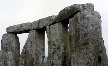
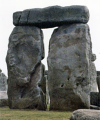 Trilithon 4, pictured above, was re-erected in 1958, having collapsed in 1797. In 2011 Stonehenge was surveyed using laser scanning equipment. The precise mapping of the stones’ exposed surfaces enabled the weight of the above-ground portions to be estimated. The left upright above (Stone 58) is estimated at 24.04 tons, the right upright (Stone 57) 27.93 tons, and the lintel (Stone 158) 16.56 tons.
 Of the thirty uprights in the circle, seventeen are now standing, and six lintels are in place.
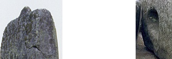
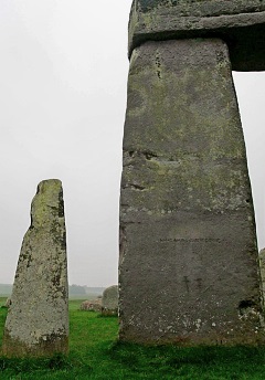 The bluestone on the left (Stone 63) has an estimated above-ground weight of 1.2 tons. The sarsen on the right (Stone 53, Trilithon 2) has an estimated above-ground weight of 18.14 tons.
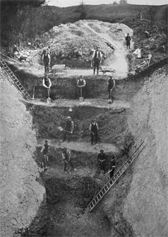 Harold St George Gray directed excavations at Avebury in 1908, 09, 11, 14 and 22. This photograph, showing his workers, vividly illustrates the ditch’s original depth.
 Stukeley wrote that the, by-then prostrate, Obelisk was: “of a vast bulk, 21 feet long, and 8 feet 9 inches diameter; when standing, higher than the rest.”
 The five remaining stones of the Southern Inner Circle, with the smaller stones of the Z Feature behind. Concrete plinths mark empty stoneholes.
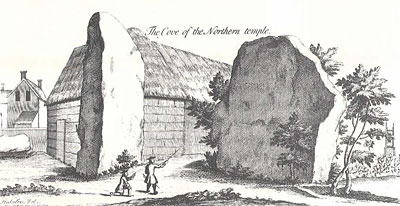 William Stukeley’s sketch of the Cove. He says that the missing, northern, wing fell down in 1713 (no doubt it was broken up for building material): “They told me it was full seven yards long, of the same shape as its opposite, tall and narrow.” Incidentally, Stukeley, mistakenly, though that, apart from their different central features, both the inner circles (“temples”) were identical – each having an outer ring of 30 stones and a concentric inner of 12.
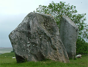 The two remaining stones of the Cove, photographed in June 2007.
 Stukeley mocks Tom Robinson in the above drawing.
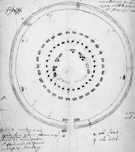
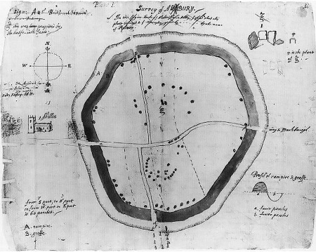 John Aubrey’s plan of Avebury.