THE FIRST FARMERS
The Neolithic: c. 4000 BC – c. 2500 BC
Farming spread across Europe from the eastern Mediterranean (wild varieties of wheat and barley, sheep and goats are native to the Near East), and arrived in Britain around 4000 BC, ushering in the Neolithic period (New Stone Age). It wasn’t just the idea of farming that arrived in Britain, but the farmers themselves. Indeed, recent genetic research tends to suggest that they arrived in such numbers as to virtually supplant the pre-existing hunter-gatherer population.[*] Also, whilst the hunter-gatherers were likely to have light eyes and dark skin, the Neolithic incomers would typically have had brown eyes and lighter skin. These migrant farmers would, of course, have had to make a sea crossing. Although there is no direct archaeological evidence, it is perhaps likely that, for such a long and potentially rough voyage, they used boats made of lightweight wooden frames covered with hides, rather than dug-out logs (of which there is evidence).
Domesticated species of cattle, sheep, goats and pigs were introduced into Britain. No doubt dogs would have assisted with the herding. (In fact, there had been domesticated dogs in Britain throughout the Mesolithic.) The animals provided milk as well as meat, however, the genetic variant that allows milk to be digested in adulthood is not present during the Neolithic, so it would have been converted into digestible dairy-products such as cheese and yoghurt. Wheat and barley were also introduced, allowing the production of bread and porridge, and possibly beer. The land would have been worked with spades, hoes, and perhaps rudimentary ploughs.
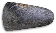
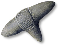
Woodland had to be cleared to create arable and grazing land – requiring the use of axes. The characteristic tool of the Neolithic is the polished axe. The axe-head would be roughed out from a suitable piece of stone or flint, and then, laboriously, ground and polished to produce the final shape and an effective cutting edge. It would be attached to a wooden haft for use. Evidently, not all axes were considered equal. In some places (such as at Cissbury Ring, in West Sussex) mine-shafts were dug in order to access subterranean flint nodules, when there was easily accessible flint available on the surface – as if the flint brought from below ground was special.[*] Axe-heads manufactured from stone quarried at certain sites, often called ‘axe factories’ (such as at Great Langdale, in the Lake District), were seemingly particularly valued, and had a wide distribution. It is clear that not all axe-heads were produced simply for use as tools. They appear to have been prized on an aesthetic level – appreciated for the beauty of the polished rock. As such, they are found in circumstances which indicate they have been purposely deposited as an offering. For instance, a polished jadeite axe-head, imported from the Italian Alps and in immaculate condition, was found alongside the Sweet Track – a raised plank walkway which traversed a reed swamp in the Somerset Levels (it is named after Ray Sweet, the peat cutter who discovered it in 1970). The Sweet Track was built in 3807/3806 BC (the precise date is thanks to dendrochronology), and it superceded an earlier track, the Post Track, which had been built in 3838 BC.
(c.3300–c.2800 BC).[*]
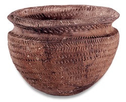
As well as farming skills, pottery making know-how also arrived in Britain. Early in the Neolithic, the round-bottomed pots – fashioned from coils, or flattened pieces, of clay – tend to be plain, and geographically homogenous. From about 3700 BC, however, regional, decorated, styles appear. Round-about 3200 BC, Grooved Ware – flat-bottomed, typically bucket-shaped, pots named after their decorative style – began to be produced. This style seems to have developed in Orkney, and spread down through Britain from there.[*]
Finds of large numbers of, bone and antler, pins (ideal for fastening leather, less so for cloth) indicate that most clothing was manufactured from animal skins – though perforated stones, which (depending on size) may have served as spindle whorls or loom weights, might suggest that woollen cloth and linen (flax being another Neolithic introduction) became available during the British Neolithic. Though obviously not British, Ötzi the Iceman probably gives an idea of the kind of clothing worn. Ötzi is the nickname given to a well-preserved corpse, dating from c.3300 BC, which, in 1991, was found protruding from a glacier in the Tyrolean Alps. With the possible exception of an outer cape made from woven grass, his garments were entirely made from animal skins. A calfskin belt held up his sheepskin loincloth and, via leather suspenders, his goat-and-sheepskin leggings. His (possibly sleeveless) coat was made from light and dark strips of goat-and-sheepskin He had a bearskin cap, with leather chin straps, and his deerskin shoes were stuffed with grass for insulation.[*]
The capstone is 5m x 2.4m x 0.9m.
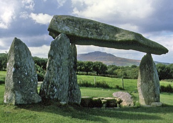
The Neolithic newcomers raised structures to house and commemorate the dead. These come in many types and sub-types, and, although they exist in substantial numbers, it is clear that not everyone ended up in one of these monuments – the individuals were selected on some basis. Monuments that were of wooden construction are, of course, no longer visible to the casual observer, but the remnants of many that were built of stone and earth can still be seen. In the west of Britain are found the simple, roofed but open-sided, megalithic structures called ‘dolmens’. Little is known about them. It seems probable that they were built very early in the Neolithic. Although human remains have been found within some dolmens, it is not certain that these spectacular skeletal structures (there is no good evidence that the spaces between the uprights were walled-in, nor that the whole thing was covered-over) were actually built, in the first place, as burial monuments.[*] Rather more is known about ‘long barrows’ – trapezoidal earthen mounds, incorporating timber or stone burial chambers – which are distributed across Britain. Long barrows appear to have first been erected shortly after 3800 BC, and to have been in vogue for the following three centuries or so. Each individual long barrow seems to have had a remarkably short primary use – human remains being deposited therein over a period of just a few generations.
dev01
The end of the active use of four Neolithic sites in South West England – Ascott-under-Wychwood, Hazleton, West Kennet and Fussell’s Lodge – was previously thought to be separated by centuries. By combining radiocarbon dates with archaeological information using Bayesian statistics, researchers have now been able to reveal that these sites, which are long barrows used as burial chambers, all ended their burial within a decade or so of 3625 BC. [None of them was constructed before 3750 BC.] … Precise dating also helps to dispel the traditional view that long barrows such as these were used over centuries. Instead, their use is now revealed to be short lived and intensive. Few barrows were used for more than three to four generations… Such short timescales support the impression of small communities keeping alive memories of their immediate kin and people they know, rather than some tribal ancestors or past heroes.See: ‘Building for the Dead: Events, Processes and Changing Worldviews from the Thirty-eighth to the Thirty-fourth Centuries cal. BC in Southern Britain’ (Cambridge Archaeological Journal Vol. 17, Issue S1, February 2007), paper freely available online.
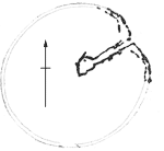
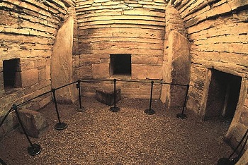
These monuments live up to their name; West Kennet long barrow, in Wiltshire, for instance, is 104 metres long – with, at its eastern end, a five chambered megalithic structure accessed by an entrance passage.
dev02
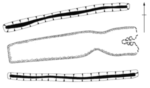 The mound of West Kennet long barrow was heaped-up from earth and chalk dug from the flanking ‘quarry ditches’. (In cases where the mound has been built from stones, the term ‘long cairn’ may be used.)
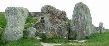 The previously mentioned research involving radiocarbon dates and Bayesian statistics suggests that the monument was built c.3650 BC, and that the remains of approximately 36 individuals (men, women and children) were deposited in its chambers over a period of only 10–30 years. There was apparently no further activity for over a century. Then the chambers were gradually filled-up with ‘secondary deposits’ of chalk, soil, animal bone, human bone and pottery. This activity continued for hundreds of years – into the second half of the 3rd millennium BC – after which a megalithic façade (pictured above) was constructed, closing-off the entrance.
See: ‘Talking About My Generation: the Date of the West Kennet Long Barrow’ (Cambridge Archaeological Journal Vol. 17, Issue S1, February 2007), paper freely available online.
The previously mentioned research involving radiocarbon dates and Bayesian statistics suggests that the monument was built c.3650 BC, and that the remains of approximately 36 individuals (men, women and children) were deposited in its chambers over a period of only 10–30 years. There was apparently no further activity for over a century. Then the chambers were gradually filled-up with ‘secondary deposits’ of chalk, soil, animal bone, human bone and pottery. This activity continued for hundreds of years – into the second half of the 3rd millennium BC – after which a megalithic façade (pictured above) was constructed, closing-off the entrance.
See: ‘Talking About My Generation: the Date of the West Kennet Long Barrow’ (Cambridge Archaeological Journal Vol. 17, Issue S1, February 2007), paper freely available online.
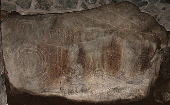
Another notable type of ‘chambered tomb’, found from Cornwall, through Wales and north-western Scotland (and, famously, in Ireland), to Orkney, is the ‘passage tomb’. In this type, a round mound covers a stone passage leading to central chambers. Well known British examples, dating from round-about 3000 BC, are Bryn Celli Ddu and Barclodiad y Gawres, both on Anglesey, and Maeshowe on Orkney Mainland.
dev03
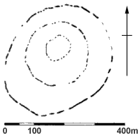
Around 3700 BC ‘causewayed enclosures’ began to be constructed. They are found almost exclusively in the southern half of England. Basically, they comprise a number (typically 1 to 3) of, roughly circular, segmented, concentric enclosing ditches – the spoil from the ditches being used to form a bank on the inner side of the circuit. The gaps between the segments are the causeways – the wider ones, which align with gaps in the adjacent bank, form entrances to the enclosure. At Windmill Hill, in Wiltshire, probably the most well known causewayed enclosure, the outer of its three encircling ditches encloses about 8.5 hectares, making it large for the type.[*] Broadly speaking, the ditches of causewayed enclosures are U-shaped, 3–4 metres wide and 1–2 metres deep. They have been found to contain not only discarded items of rubbish, like broken pottery, animal bones and flint knapping waste, but also items which appear to have been formally placed, such as human and animal burials, human skulls, axe-heads and complete pots (which possibly contained food or drink when deposited). The purpose of causewayed enclosures is much debated, but a popular theory is that they served as meeting places, where neighbouring groups could congregate for purposes of trade or ritual. Having said that, some causewayed enclosures evidently adopted the role of defended settlements (such as Crickley Hill, in Gloucestershire, and Carn Brea, in Cornwall).
dev04
The first major occupation at Crickley was a causewayed enclosure … Two lines of interrupted ditches cut off the low knoll in the centre of the promontory. Behind each line ran a bank, built of the stone taken from the ditch, through which at least two entrances had been built. The inner ditches had been filled in, and were then partially recut and backfilled several times, a process which implies a lengthy but perhaps intermittent use of the site… After the final filling-in of the old ditches a new and larger ditch was dug parallel to the inner causewayed line. The old ditch was still visible, but was avoided, and a new bank was piled above it, faced with drystone walls and surmounted by a fence. At least two entrances were in use.Carn Brea is of a type (comparable to the causewayed enclosure), peculiar to the south-west, known as a ‘tor enclosure’ (a hilltop or hillslope enclosure, located close to rock outcrops, and surrounded by one or more circuits of stone built walls). Roger Mercer excavated the site in the early-1970s:Crickley Hill and Gloucestershire Prehistory (1977), freely available online.
… a hilltop village two acres [0.8 hectares] in extent was located, defended by a massive stone wall [up to 2 metres wide at its base, and originally, perhaps, 2 metres high] that enclosed a series of platforms upon which traces of structures were located… Outwith this enclosure were traces of what were interpreted by the writer as clearance cairns and patches of cleared soil for the growing of crops and these and the enclosure were surrounded by a greater fortified enceinte with clearly defensive gateways that also appeared to be Neolithic.‘The Neolithic in Cornwall’, in Cornish Archaeology Vol. 25 (1986), freely available online.
The traditional view is that the Neolithic was a peaceful age, but there is now a considerable body of evidence highly suggestive of warfare. For example, at both Crickley Hill and Carn Brea, hundreds of leaf-shaped arrowheads, found clustered around entrances, and associated with evidence of burning, are indicative that the sites came under attack. Causewayed enclosures themselves evidently ceased being built c.3500 BC, but they represent the beginning of a process of ceremonial enclosure development which culminated with the most famous prehistoric structures in Britain[*].
Neolithic houses were generally rectangular in plan and built of wood – they would have had plank or wattle-and-daub walls and thatched roofs – but they are relatively poorly represented in the archaeological record. This may be simply because they are not easy to spot in the landscape – virtually all that remains of them being filled-in postholes – but the apparent rarity of Neolithic dwellings in Britain has led to the suggestion that these early farmers did not, necessarily, remain in one place all the time, but moved around within a defined area – a pattern of behaviour known as ‘tethered mobility’.[*] In Orkney, however, there are the remains of stone-built Neolithic settlements, the most famous of which is undoubtedly:
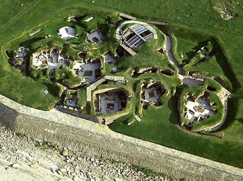
SKARA BRAE
… the best-preserved Neolithic settlement in Western Europe.
In 1850 a great storm battered the Bay of Skaill, on Orkney Mainland, stripping the surface from the large grass-covered sand-dune known as Skerrabra (now Skara Brae), and revealing traces of stone buildings. The local laird, William Watt, took an interest in the site, and by 1868 four houses had been cleared. Except for some casual exploration, Skara Brae was left undisturbed for the next 50 odd years. In 1924 William Watt’s trustees handed Skara Brae into State care. In 1925 another storm caused damage to the site – which resulted in the construction of a protective sea-wall. Investigations carried out in 1927 found that there were other buildings still buried. Between 1928 and 1930, Skara Brae was excavated by Vere Gordon Childe, and the site visible today was exposed. Further excavation, under the direction of David Clarke, took place in 1972 and 1973, when the first samples for Radiocarbon dating were collected.
from Phase 1.
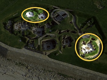
The full extent of the settlement is not known. Some (how much?) has been lost to erosion on the seaward side, and geophysical survey hints at unexplored remains inland. The buildings that can be seen at Skara Brae today are from two phases of development – of the ten buildings exposed, two belong to the earlier phase, Phase 1. In 2017, Bayesian-modelling, using the considerable number of Radiocarbon measurements by then available, suggested that Phase 1 was built round about 2900 BC, and was seemingly abandoned within a century[*]. The site was re-occupied in the 2700s BC, and Phase 2 was built over the flattened remains of Phase 1. Phase 2 was not built to the same plan as Phase 1 – it was not simply a house for house replacement – hence the visible remains of two houses from Phase 1. One of those earlier houses was heavily robbed out, perhaps to provide materials for new buildings. Sufficient is left of the other, however, to show that the new houses were similar in layout to the earlier houses, but larger.
The houses’ drystone walls are double-skinned – the cavity between skins being packed with varied conglomerations of clay, sand, ash and domestic-refuse, to aid stability and provide insulation. Clay was also used for foundations and to clad outer walls. The houses are huddled close together. The narrow passageways between them are generally floored with flagstones, and some were, at some stage during the settlement’s evolution, roofed over with stone slabs and covered in clay and turf. (The long-lived notion that the settlement was, in effect, subterranean – that the houses were buried within a mound of ‘midden’ and connected by tunnels – is not substantiated by the archaeological evidence[*].)
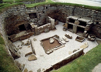
Entry to each house is through a low doorway – the door itself would have been a stone slab, held in place by a beam fitting into slots in the stonework. Inside the house is a central, rectangular, hearth and, on the wall opposite the door, a stone ‘dresser’. On either side wall are stone box beds which would have been filled with bracken or heather, and covered with animal pelts. It is suspected that the beds would have had a canopy and curtains, in the fashion of a four-poster. There are alcoves and compartments (known as ‘cells’), of various sizes, set into the room walls. Most are clearly storage spaces, however, some cells have drains running under them, and it is thought possible that these were indoor toilets. Nothing remains of the roof structures. Then, as now, trees on Orkney were in short supply, so whalebone or driftwood rafters may have supported roofs of thatch, turf or skins.
There is one building at Skara Brae that stands apart from the village huddle. It is separated from the main entrance passageway by a paved area (known as ‘the marketplace’, though there is nothing to suggest that that is what it actually was), and, except for the central hearth, it has none of the interior features of the houses. Since the floor was found to be littered with chert fragments, suggesting that tools were made there, it is thought to have been a workshop. (There is a possibility that this ‘workshop’ is later than the other buildings.)
The local chert cannot be given as sharp an edge as flint, but there is only a small amount of flint available – found as pebbles on the beach. The commonest type of stone tools unearthed at Skara Brae are made from pebbles. These tools were dubbed ‘Skail flakes’ (sic) or ‘Skail knives’ (sic) by Professor Childe:
Such a knife can, in fact, easily be made by dashing a rounded piece of local shaley stone from the beach sharply on the ground, when it breaks along the bedding-plane, yielding a flake of the required form.V. Gordon Childe ‘Provisional Report on the Excavations at Skara Brae’
Proceedings of the Society of Antiquaries of Scotland Vol. 63 (1929)
These simple knives have been found to be remarkably effective as butchering tools. However, many utensils – scrapers, awls, mattocks, shovels etc. – were made from bone (and in all probability wood, but that tends not to be preserved).
The farmers of Skara Brae raised cattle, sheep/goats and, to a lesser extent, pigs. They grew cereals – mainly barley, but some wheat. They also hunted the local wild animals, seabird eggs, and fish. Although no fishing equipment has been discovered, set into the floor of each house are watertight tanks which, it is conjectured, could have been used for keeping fish bait. They produced Grooved Ware pottery, but there is no evidence of spinning or weaving.
dev05
The Skara pottery is, in fact, the worst I have ever handled. It is so coarse and badly baked that for a time I mistook the first large lump of it I came across in the midden for a plaster hearth, such as are so often met in Danubian settlements. Skara pottery is so badly fired that when first uncovered in the midden it can be cut with a penknife. In the damper environment of a hut floor it is sometimes literally plastic. On drying in the sun it soon becomes friable. No complete vessel could be rescued. The majority of the sherds come from the midden, and even there the rims have been so distorted by pressure that the original curvature can no longer be estimated… The larger vessels were built up in sections. The lower ring was pinched and flattened on its upper rim to a bevelled edge, the next ring was forced over this and smoothed down on either side when the lower ring was already drying… It was impossible to reconstruct the shape of any of these coarse vessels, but all had flat bottoms and the sides were probably almost straight. Besides this coarse, thick ware a few fragments of smaller vessels were discovered. These were a little finer in texture and a trifle better fired, but still very coarse, unpolished, and far from solid. The fragments seem to come from small round-bottomed bowls or dishes. Despite its coarseness the great majority of the pots found had been ornamented, generally just below the rim.‘Provisional Report on the Excavations at Skara Brae’
Proceedings of the Society of Antiquaries of Scotland Vol. 63 (1929), freely available online.
They also made jewellery (beads, pendants and pins) and objects which would appear to be gaming pieces. Some walling stones have been decorated with geometric, carved, patterns, which may have been coloured originally – ‘paint pots’, made from oyster shells, whale vertebrae and stone, were found. Also found were some, abstract, objects which may have had a ritual purpose.
Skara Brae (at least the part of the settlement that has been excavated) was finally abandoned around 2500 BC. Professor Childe imagined that the inhabitants were forced to flee as it was wrecked by a catastrophic storm. There is, though, no persuasive evidence of such a dramatic end. The reason for its abandonment is not certainly known.
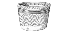 Illustration of a Grooved Ware pot from Clacton, Essex. (Grooved Ware was previously known as Rinyo-Clacton Ware, after Clacton and another find-spot: Rinyo, on the Orkney island of Rousay.)
 Windmill Hill causewayed enclosure is the earliest dated monumental structure in the Avebury World Heritage Site. Bayesian analysis of radiocarbon dates indicates it was built in the decades around 3650 BC – the inner and outer circuits were first, at which point West Kennet long barrow (2½ miles to the southeast) was constructed, then came the middle circuit – this whole sequence taking no longer than 75 years.
See: ‘Avebury Resource Assessment’ Parts 1 and 2 (2016), freely available
Windmill Hill causewayed enclosure is the earliest dated monumental structure in the Avebury World Heritage Site. Bayesian analysis of radiocarbon dates indicates it was built in the decades around 3650 BC – the inner and outer circuits were first, at which point West Kennet long barrow (2½ miles to the southeast) was constructed, then came the middle circuit – this whole sequence taking no longer than 75 years.
See: ‘Avebury Resource Assessment’ Parts 1 and 2 (2016), freely available