In 83, Agricola (governor of the Roman province of Britain, 77–84) had routed the combined forces of the tribes of Caledonia at Mons Graupius (an unknown site in northern Scotland).[*] An account of this battle forms the climax of a biography of Agricola, written by, his son-in-law, Tacitus. Under Agricola’s leadership, says Tacitus (Agricola 10), Britain had at last been “completely conquered”. On the heels of his victory, Agricola was recalled to Rome, and Tacitus makes no further reference to Britain in the biography. However, in an introductory passage in his later work, the Histories (I, 2), Tacitus again states “Britain was completely conquered”, but adds: “and immediately let go”. Presumably he expanded on this headline remark later, but unfortunately his story has not survived. Tacitus had a personal reason for taking note of British affairs, but, sadly, his particular interest does not appear to have been shared by other writers. Between Agricola’s return to Rome, in 84, and Hadrian becoming emperor, in 117, there is a gaping hole in the literary record of events in Britain. Archaeological evidence, though, indicates that during this period the Romans vacated the country north of the Tyne-Solway line.
Coin finds appear to date, with reasonable precision, a complete Roman withdrawal from Caledonia (i.e. from beyond the Forth-Clyde) to between late-86 and mid-87.[*] By the time the decision to retreat was taken, a series of forts (sometimes called ‘glen-blocking’ forts) had been built along the edge of the Highland massif, and, at Inchtuthil in Perthshire, the most northerly legionary fortress of the Empire was under construction. To their south was a line of forts, fortlets and watch towers, known as the ‘Gask Ridge frontier’. On the strength of Tacitus’ narrative, all this building (and no doubt there is more still to be discovered) has traditionally been attributed to Agricola and his unknown successor. Excavation at several watch towers of the Gask Ridge, however, has produced evidence that they were totally rebuilt at least once, possibly twice. Since the date of abandonment seems to be fixed at 87, this suggests that the ‘frontier’ was established earlier than had been suspected. A poem, by Publius Papinius Statius (published c.95), in praise of Crispinus – the son of Vettius Bolanus, who governed the province of Britain 69–71 – contains the passage:
But if a land curbed by your great parent receives you, how the savage Araxes will exult! What glory will excite the Caledonian plains, when some aged inhabitant of the savage country relates, “Here your parent used to give judgement, on this turf address the squadrons; he placed watchtowers across wide tracts, and forts a long way off – do you see them? – and surrounded these walls with a ditch …”
Silvae 5.2, lines 140–146
D.J. Woolliscroft, a director of the Roman Gask Project, has noted that Statius’ watchtowers and forts are “rather familiar sounding”.[*] At any rate, in 86/7 the Romans demolished the, still unfinished, fortress at Inchtuthil, and, in an orderly fashion, vacated Caledonia. Why? Well, it seems that Britain had become a low priority: a whole legion, Legio II Adiutrix Pia Fidelis, and probably auxiliary units as well, was withdrawn for service on the Danube; presumably the remaining forces would have been too thinly spread to maintain, let alone extend, the Roman grip on this large, remote and geographically challenging territory.
wall01
The 2nd Legion Adiutrix (Legio II Adiutrix Pia Fidelis) should not be confused with the 2nd Legion Augusta (Legio II Augusta), which was in Britain for the whole Roman period.[*] Adiutrix means ‘assistant’ or ‘helper’, and they were raised during the civil wars of 69 (Year of the Four Emperors). It is likely that they came to Britain with Petillius Cerialis, when he began his tenure as governor in 71, but there is actually no literary record at all of the legion’s posting to Britain. The evidence comes from various inscriptions, which indicate that they were stationed in the fortress of Lindum (Lincoln) and then the fortress of Deva (Chester), that they took part in “the Dacian War” and that they were in Moesia by 92.[*] In c.85 the Dacians had attacked the Roman province of Moesia, killing its governor. A Roman counter-offensive, c.86, was heavily defeated. Reinforcements were required, and it is generally thought that the 2nd Adiutrix was withdrawn from Britain at this time. The Romans defeated the Dacians in c.88, but other dangers obliged Domitian to come to terms.[*]
After the 2nd Adiutrix’s departure, the fortress of Deva was evidently occupied by the 20th Legion (Legio XX Valeria Victrix) – it is usually supposed that Inchtuthil was intended to be the 20th’s HQ. About 90, a colonia (colony of legionary veterans) was established on the vacant fortress site at Lindum. Later, during the reign of Nerva (96–98), another colonia was founded on the site of the redundant fortress of Glevum (Gloucester).
At the end of the 1st century, then, there were three legions in Britain – the 20th based at Deva, the 2nd Augusta at Isca (Caerleon, near Newport) and the 9th (Legio IX Hispana) at Eboracum (York). During the first decade of the 2nd century, the earth and timber defences at these remaining three fortresses were replaced with stonework.[*]
The Stanegate
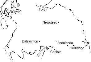
Though they had left, what is today, northern Scotland, the Romans retained a military presence in southern Scotland, indeed, the forts at Newstead (Trimontium) and Dalswinton were enlarged. (The territory between the Forth-Clyde line and the Tyne-Solway line comprises southern Scotland and, to the south-east, a wedge of northern England, but for convenience the whole region will be referred to as southern Scotland.) However, they also built a series of forts along the route of the Stanegate – the Roman road between Corbridge (Coria) and Carlisle (Luguvalium), on the Tyne-Solway line. One of them, Vindolanda, is famous for the hundreds of writing tablets that have been found there.[*] Early in the 2nd century, round about 105, it seems that the Romans abandoned those forts north of the, so called, ‘Stanegate frontier’. It may be that further troop withdrawals – including Vindolanda’s garrison, the 9th Cohort of Batavians – had necessitated the evacuation of southern Scotland, especially if the local Britons were proving hostile. Evidence unearthed at Newstead could indicate that the fort was destroyed during warfare.[*]
wall02
There is no surviving literary record of affairs in Britain at the time when the Romans appear to have retreated from Caledonia to the Stanegate. Suetonious mentions that a governor of Britain, Sallustius Lucullus, was executed on Domitian’s orders:
… for allowing some lances of a new pattern to be called ‘Lucullean’, after his own name …
Lives of the Twelve Caesars ‘Domitian’ 10
Presumably this, otherwise unknown, individual was guilty of (or suspected of) a somewhat greater transgression than simply naming a lance after himself, but all that can be said of him with certainty is that he served and was executed sometime between the departure of Agricola, in 84, and Domitian’s assassination, in 96. A fleeting mention in a satirical poem by Juvenal might point to native unrest during that same period. A “turbot of wonderful size” is said to be an omen:
… “you [Domitian] have a gigantic omen of great and glorious victory. You will take some monarch prisoner; or else Arviragus will tumble from the pole of a British chariot…”[*]
Satires IV, lines 124–127
Arviragus (assuming he is a real historical figure) is not mentioned in the surviving texts of Tacitus – he could possibly have featured in a now-lost section of the Histories.
A tombstone inscription from Cyrene (L’ Année épigraphique 1951, 88) commemorates one Gaius Julius Karus, a military tribune of Legio III Cyrenaica, who had, before his posting to north Africa, been prefect of Cohors II Asturum (2nd Cohort of Asturians), a cohors equitata, and had been highly decorated in “the British War”.[*] At one time it was thought that Karus must have earned his decorations between 89 and 117. The latter date, 117, because Hadrian, who became emperor in that year, was rather stingy with his awards, and III Cyrenaica moved to Arabia during his reign. The former date, 89, is based on the assumption that the 2nd Cohort of Asturians was until then, at the earliest, based in Germany. It now seems, however, that at that time there were two 2nd Cohorts of Asturians – one in Germany and another in Britain – so the date of Karus’ “British War” is suddenly rather less constricted. Whilst he could have received his honours during the last years of Domitian, the brief reign of Nerva (96–98) or the reign of Trajan (98–117), distinguishing himself in some unrecorded campaign, he may well have earned them on a well-known earlier occasion – at Mons Graupius with Agricola.[*]
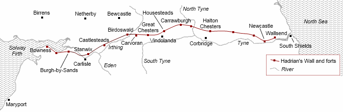
Hadrian’s Wall
There was certainly warfare in Britain during Hadrian’s reign (117–138). In a letter written to Marcus Aurelius, in 162, the orator Marcus Cornelius Fronto comments:
… under the rule of your grandfather Hadrian what a number of soldiers were killed by the Jews, what a number by the Britons!
De bello Parthico 2
Hadrian succeeded Trajan as emperor in 117.
On taking possession of the imperial power Hadrian at once resumed the policy of the early emperors, and devoted his attention to maintaining peace throughout the world. For the nations which Trajan had conquered began to revolt; the Moors, moreover, began to make attacks, and the Sarmatians to wage war, the Britons could not be kept under Roman sway, Egypt was thrown into disorder by riots, and finally Libya and Palestine showed the spirit of rebellion.
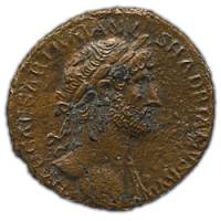
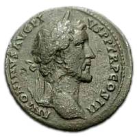
(•)A copper ‘as’ of Hadrian, dated 119/120.[*] Britannia is armed with spear and shield, she is wrapped in a cloak, sitting on a pile of rocks (which probably symbolize mountainous terrain).
Probably in 118, Hadrian transferred Quintus Pompeius Falco, the governor of Moesia Inferior, to Britain. Coins issued in 119–120, for the first time depicting the figure of Britannia, the personification of the Island, are widely believed to commemorate Falco’s military success in Britain.
A partial inscription (RIB 3364), in a style indicative of the first quarter of the 2nd century, from Vindolanda – on a memorial slab which had been incorporated into the fabric of a later (4th century) phase of construction – evidently records that Titus Ann[ius? …], a centurion of a cohort of Tungrians, was “killed in the war”. Presumably this was the 1st Cohort of Tungrians – the unit that replaced the 9th Cohort of Batavians at Vindolanda in about 105.[*] Perhaps the centurion was killed during Falco’s campaign?
An inscription from Camerinum in Italy (ILS 2735) records that one Marcus Maenius Agrippa had been “chosen by the deified Hadrian and sent on the British expedition”. An inscription from Ferentinum in Italy (ILS 2726) records a force, comprising thousand-man detachments from each of three legions – VII Gemina (based in Spain), VIII Augusta and XXII Primigenia (both based in Upper Germany) – commanded by Titus Pontius Sabinus, senior centurion of III Augusta (based in North Africa), “on the British expedition”. A bronze boss from the shield of a legionary of VIII Augusta was dredged from the riverbed near the mouth of the Tyne in 1867. Now, the date of this “British expedition” is a subject of much debate. It seems that the word ‘expedition’ (expeditio) normally indicates that the emperor himself was present. As we shall see, Hadrian visited Britain in 122, however, the inscription from Ferentinum lists the career of Titus Pontius Sabinus, and this suggests a date a few years later than 122. There is no scholarly consensus.
What does seem clear, though, is that the Britons who inflicted great losses on the Roman army during Hadrian’s reign were tribesmen from beyond the Tyne-Solway line, in southern Scotland.
Unlike other emperors, Hadrian toured widely in the Empire. In 121 he left Rome:
… he travelled to the provinces of Gaul, and came to the relief of all the communities with various acts of generosity; and from there he went over into Germany…
… having reformed the army quite in the manner of a monarch, he set out for Britain, and there he corrected many abuses and was the first to construct a wall, eighty miles in length,[*] which was to separate the barbarians from the Romans…
After arranging matters in Britain he crossed over to Gaul …
… the poet Florus wrote to him:
“I don't want to be a Caesar,
Stroll about among the Britons …”
Historia Augusta ‘Hadrian’ 10, 11, 12, 16
Hadrian arrived for his “stroll about among the Britons” in 122. He was probably accompanied by the newly appointed provincial governor, his friend and ex-governor of Germania Inferior (Lower Germany), Aulus Platorius Nepos – Nepos is known, from a military diploma (CIL XVI, 69), to have been in Britain by 17th July 122. The wall that Hadrian ordered to be built was along the Tyne-Solway line.
Hadrian’s Wall was built slightly north of the Stanegate. Excavation has indicated that the original plan was for a stone wall, 10 feet wide, between modern central Newcastle and the river Irthing. Between the Irthing and Bowness-on-Solway the wall was to be built with turf blocks – the traditional method for such military structures. There was to be a fortlet every mile, hence they are known as ‘milecastles’ (they were, in effect, fortified gateways), with two turrets spaced evenly between each pair of milecastles.
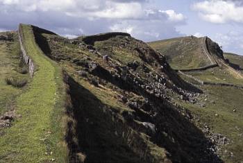
Hadrian’s Wall snakes away to the west of Housesteads. Where it fronts onto the crags of the Whin Sill, there is no ditch.
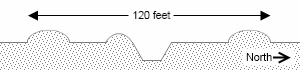
A V-shaped ditch was to run in front of the wall (i.e. to its north), except where cliffs made it unnecessary.
Probably also part of the initial scheme: a line of fortlets and towers, but no wall, continuing down the coast from Bowness to, at least, Maryport.
After a couple of years work (i.e. from c.124), however, the plan changed. The stone wall was built to a reduced width of 8 feet – presumably to speed up construction. It was decided that some forts should be added, which involved the demolition of newly built sections of wall, milecastles and turrets. To the south of the wall and forts, a substantial ditch-and-mound barrier, called the Vallum, was built. The stone wall was extended 4 miles eastwards from Newcastle, to a new terminus at Wallsend.
Epigraphic evidence from the Wall suggests that the majority of the work was carried out during Nepos’ tenure as governor – which cannot have extended beyond summer 127, since a military diploma names Britain’s governor as Trebius Germanus on 20th August 127.[*]
wall03
On the western, 31 Roman mile long, turf section of the Wall, though the milecastles were of turf and timber construction, the turrets were built in stone. The reason for the east-west division of building techniques is not known – a paucity of building-materials in the west has been widely suggested (although the turf wall was already being replaced by stone during Hadrian’s lifetime). Actually, turf and timber construction was the usual military method, and it is conceivable that some of the Wall had already been built before Hadrian’s arrival and personal intervention. Architecture was a particular interest of Hadrian, so it is not unreasonable to assume that his opinions dictated the initial design of the Wall. Indeed, the bridge over the Tyne at Newcastle (the Wall’s original terminus) was named Pons Aelius after Hadrian (Publius Aelius Hadrianus). The fort at Newcastle (which was detached from the Wall, on a promontory overlooking the Tyne and bridge), also called Pons Aelius, was a much later addition – evidently at the end of the 2nd or early in the 3rd century. Much, much later, the Normans planted the new castle that gave the town its name on the same site.
Excavations of the berm (the ledge between wall and ditch), at places along the easternmost section (roughly a dozen miles) of the Wall, have, since 2000, uncovered rows of pits. It is thought that they held obstacles – branched, sharpened stakes – acting like barbed wire would today.[*]
The Vallum comprises a steep-sided, flat-bottomed, ditch, some 9 feet deep and 20 feet wide – there were crossing points (gated causeways) associated with the Wall forts – with a 20 foot wide mound around 30 feet distant on either side. (For much of its length, there is a third mound, the so called ‘marginal mound’, on the southern edge of the ditch. It seems to be a design feature, rather than the result of ditch cleaning-out operations, but it may be a later development.[*]) Where topography allows, the Vallum runs close to the Wall, and in these sections it loops around the Wall forts – hence the Vallum cannot predate the forts. The fort at Carvoran was one of the earlier Stanegate forts, kept on for service as a Wall fort. Consequently, it is detached, by some 240 yards from the Wall. Here, the Vallum runs between fort and Wall. At Castlesteads, however, where the fort is 140 yards further from the Wall (it is not known whether this fort has pre-Hadrianic origins), the Vallum diverts to encompass it. At any rate, elsewhere, such as in the central section where the Wall sits atop Whin Sill, the Vallum runs in long straight stretches on the nearest feasible line. At its greatest distance, it is around ½ mile from the Wall. It is generally supposed that the Vallum’s purpose was to create a secure zone behind the Wall.
Inscriptions commemorate contributions by the 6th Legion (Legio VI Victrix Pia Fidelis), which probably transferred to Britain from Germania Inferior with Nepos, 2nd Legion and 20th Legion to the construction of Hadrian’s Wall, but not the 9th Legion (Legio IX Hispana). Gallons of scholarly ink has been expended theorising on the fate of the 9th Legion, which had evidently ceased to exist by c.165.[*] An inscription from York (RIB 665) certainly places the unit in Britain in 108. It is, though, possible that it worked on the turf section of the Wall, from which there are no stone inscriptions.[*] Perhaps it was withdrawn from Britain when the Wall project was sufficiently complete to allow for a reduction in manpower.[*] The 6th Legion superceded the 9th in the fortress at York.
The Wall fort at Carrawburgh was added as an afterthought, since it overlies the Vallum. A fragmentary inscription (RIB 1550) tends to indicate it was built in the early 130s. Apparently before the end of Hadrian’s reign (i.e. by 138), a 5 mile length (at least) of turf wall, west from the Irthing, was replaced in stone.
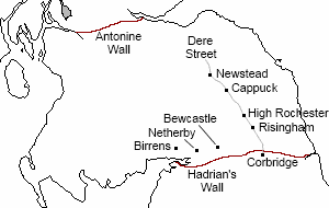
No part of Hadrian’s Wall has survived intact, but it is generally estimated to have been about 15 feet high – probably topped by a walkway with a parapet on the northern side. Beyond the Wall, ‘outpost-forts’ at Birrens, Netherby and Bewcastle were garrisoned.
wall04
The governor named on a fragmentary dedication slab from the fort at Carrawburgh (RIB 1550) seems to be Julius Severus, who was governor c.131–c.133. (Platorius Nepos is the only Hadrianic governor who is definitely named in inscriptions from the Wall.) A dedicatory inscription from the fort at Great Chesters (RIB 1736) refers to Hadrian as Pater Patriae (Father of his Country), a title he accepted in 128 – suggesting that the fort was not completed until then at the earliest. Hadrian had, however, been offered, but had turned down, the title previously, and there are instances where inscriptions from before 128 credit him with the title though he hadn’t officially accepted it – for example, a milestone from Thurmaston, near Leicester (RIB 2244), is dated 120, but acknowledges Hadrian as Pater Patriae. The fort at Great Chesters, then, was probably, but not necessarily, completed after 128.
Five miles of turf wall west of the river Irthing, i.e. the easternmost five miles of turf wall, were evidently replaced during Hadrian’s reign (Milecastle 49 to Milecastle 54). There may have been more, but insufficient evidence has been found. David J. Breeze notes:
It can be firmly stated that it is not possible to place a western limit on the rebuilding of the Turf Wall in stone under Hadrian from the point of view of the structures nor from the evidence of the wall itself as so little of it has survived anywhere… it is possible that the western boundary of the sector rebuilt under Hadrian lay further west than hitherto supposed.
‘The Civitas Stones and the Building of Hadrian’s Wall’, Transactions of the Cumberland & Westmorland Antiquarian & Archaeological Society Third Series, Vol. 12 (2012), freely available online.
The ex-Stanegate fort at Carvoran was also rebuilt in stone. The fort at Birdoswald, the first Wall fort west of the Irthing, was similarly rebuilt in stone – though the work was possibly not completed at this time. In fact, either side of Birdoswald (Milecastle 49 to Milecastle 51) is the only place where, so far as is known, the replacement stone wall (in the fullness of time, the remaining turf section would be replaced) takes a different line from the turf wall.
Birdoswald was connected by road to the outpost-fort at Bewcastle. The other two outposts were accessed from Carlisle. (There is evidence to suggest that Hadrian’s Wall had cut across the territory of the Brigantes, in the west, and it is widely suggested that these outpost-forts were sited to guard those Brigantes now marooned beyond the Wall.) Carlisle may well have been area headquarters – Tablet 250 from Vindolanda, with its reference to “Annius Equester, centurion in charge of the region, at Luguvalium [Carlisle]” certainly indicates that was the case before the Wall was built. There were two main routes through the Wall. One was from Carlisle, the other was the Roman road known as Dere Street. Dere Street began in York, passed through Corbridge and crossed the Wall at a substantial gateway (known as Portgate) ½ mile west of the fort at Halton Chesters. It is assumed that there would have been a similar gateway, serving the road from Roman Carlisle, to the west of the fort at Stanwix, though it has not yet been found. (The fort and most of its surrounds are buried under Stanwix, which is a suburb of modern Carlisle.)
The two forts which complete the Wall’s complement of sixteen are considerably later additions. Both date from the end of the 2nd or early in the 3rd century. They are the previously mentioned fort at Newcastle and the fort at Burgh-by-Sands. This latter Wall fort apparently superseded a fort sited over ½ mile to the south. A fort was built on the south bank of the mouth of the Tyne, at South Shields, c.160, but it is thought that there is an earlier, yet to be discovered, fort in the vicinity.
The Antonine Wall
On 10th July 138 Hadrian died. He was succeeded by Antoninus Pius.
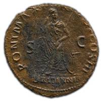
He waged a number of wars, but all of them through his legates [i.e. his provincial governors]. For instance Lollius Urbicus, his legate, overcame the Britons – another wall, of turf, being set up when the barbarians had been driven back.[*]
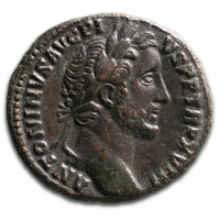
(•)A bronze sestertius of Antoninus Pius, depicting Britannia holding a legionary standard in her right hand; the legend IMPERATOR II arching around her.[*]
It was apparently soon after his accession that Antoninus Pius ordered the provincial governor, Quintus Lollius Urbicus, to abandon Hadrian’s frontier, and to retake southern Scotland. No doubt there had been provocation from beyond Hadrian’s Wall, but there may also have been a less direct reason for such dramatic action. Antoninus was actually Hadrian's second choice as successor (his first choice, Lucius Aelius, died on 1st January 138), and he had no military experience. Like Claudius a century before, he might have felt that he needed a conquest to establish his credentials with the army and secure his position. At any rate, in 139 Lollius Urbicus was already at work reconstructing the fort at Corbridge – including, it seems, building new stone granaries – preparatory to the advance.[*] Urbicus delivered the emperor a victory – probably in the summer of 142, at which time Antoninus was acclaimed ‘Imperator for the second time’.[*] Coins commemorating the event were issued. Southern Scotland was again under Roman occupation, and a new frontier wall was built on the Forth-Clyde line.
wall05
In sharp contrast to Hadrian, Antoninus Pius, in over twenty-two years as emperor, never left Italy. Marcus Cornelius Fronto apparently made a speech (possibly delivered in 142, at the time he became consul) in which he praised Antoninus on his British success. The speech itself no longer exists, but it is referred to in the, end-of-3rd-century, ‘Panegyric on Constantius Caesar’:
At this point it enters my mind how pampered by good luck in administrating the State and obtaining praise were those leaders who, while spending their days at Rome, had triumphs and cognomina of nations conquered by their generals accrue to them. Thus when Fronto … was praising the ruler Antoninus for having brought the war in Britain to completion, although he had remained behind in the City in the palace itself, and had delegated the command of the war to others, he averred that the Emperor deserved the glory of its whole launching and course, as if he had actually presided at the helm of a warship.
Panegyrici Latini, VIII ‘Panegyric on Constantius Caesar’ 14 (Anonymous)
Writing in the late-170s, in a brief run-through of highlights from Antoninus’ rule, the Greek traveller and geographer Pausanias notes that:
… [Antoninus] never willingly involved Rome in a war… He annexed the greater part of the territory of the Brigantes in Britain, because the Brigantes started an invasion of Genounia, which is subject to Rome.
Description of Greece VIII, 43
Pausanias’ comment, though, doesn’t make much sense. He implies that the Brigantes were outside the Roman province of Britain, which, of course, they weren’t – unless he means the (possible) small minority who had been isolated beyond Hadrian’s Wall – and what is meant by “Genounia” is not known. The Brigantii – based around the modern city of Bregenz, Austria – of the province of Raetia, had neighbours called the Genauni, so it could be that Pausanias has confused these Brigantii with the British Brigantes, or perhaps Pausanias’ text has been corrupted in transmission. Sheppard Frere* suggests that, though there may well be confusion in Pausanias’ text, he really is talking about Britain, since the advance to the Forth-Clyde line was Antoninus’ most important military achievement, and that he is using the term Brigantes, not in the specific sense, but as shorthand for ‘the inhabitants of northern Britain’.
* Britannia: A History of Roman Britain Third Edition (1987), Chapter 7.
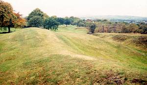
The Antonine Wall looking west from Rough Castle. The rampart is on the left and the ditch on the right.
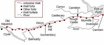
The new wall, known as the Antonine Wall after the emperor, ran across the narrow neck of land between the Forth and Clyde – a distance of some 40 Roman miles (half the length of Hadrian’s Wall). The rampart was built from turf blocks, and was 15 feet wide at the base. This is narrower than the turf section of Hadrian’s Wall, which was 20 feet wide, but the structure of the Antonine Wall was rather more sophisticated, having a stone foundation with built in drainage culverts. The turf rampart is estimated to have been around 10–12 feet high, with, presumably, a wooden walkway and parapet on top. The V-shaped ditch to its north, at up to 40 feet wide and 12 feet deep, was a more imposing feature than the ditch at Hadrian’s Wall. The material dug from the ditch, piled up on the northern lip (a ‘glacis’), enhanced the obstruction. It seems that, initially, the idea was to have six forts (known as the ‘primary forts’) spaced along the rampart, with intervening fortlets (no turrets). Just as at Hadrian’s Wall, however, the plan changed, and extra, generally smaller, forts – eleven are known – were added. To the south of the rampart was the Military Way – a road running the whole length of the Wall.
wall06
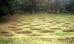
Beyond the ditch and glacis at Rough Castle is an area of closely spaced pits, aligned like laid bricks to prevent a straight passage through them, which would have held pointed stakes – a type of trap known as lilia. In places, similar pits have been found on the berm.
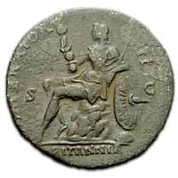
In fact, the eastern terminus of the Antonine Wall has not been found. It is widely assumed to be in the vicinity of Bridgeness Tower, Bo'ness, where, in 1868, a massive ‘distance slab’ was found. However, the easternmost fort of the system, at Carriden, is about ¾ mile further east than this assumed terminus.
The Antonine Wall’s six primary forts, approximately eight miles apart, were at: Carriden, Mumrills, Castlecary, Bar Hill or Auchendavy (it isn’t clear which of these two is the primary – Bar Hill is detached from the Wall, set to the south, on the brow of a hill), Balmuildy and Old Kilpatrick. Three of these were evidently built before the Wall reached them: Castlecary, Balmuildy, and Old Kilpatrick (the western terminus of the Wall). Usually, Wall forts had turf ramparts (with stone principal buildings), however, Castlecary and Balmuildy had stone ramparts. The northern defences of forts on the Antonine Wall do double duty as the Wall itself.[*] At Balmuildy there are stone ‘wing walls’ protruding from the northern corners, as if in the expectation that the Wall they connected with would be stone. It is not impossible that the original plan was to build the whole Antonine Wall in stone. Added on to many (maybe all) forts were defended enclosures, known as ‘annexes’, which often contained the bath-house.
There are at least six southward extensions of the Wall’s rampart, referred to as ‘expansions’, the purpose of which is not clear, though, perhaps, beacon platforms is the most likely suggestion.
Inscriptions on decorated ‘distance slabs’ commemorate the efforts of the 2nd, 6th and 20th Legions in constructing stretches of the Antonine Wall. Lollius Urbicus is named on two building inscriptions from the primary fort at Balmuildy (RIB 2191 and RIB 2192), which was one of the first elements of the Wall to be constructed. It seems likely that having made a start on the new frontier, Urbicus was promptly withdrawn from Britain – none of his successors are named in inscriptions from the Wall.
wall07
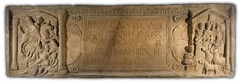
The left-hand panel symbolises the might of Rome crushing the naked barbarians. The right-hand panel depicts the suovetaurilia – the sacrifice of a boar, a ram and a bull, which would precede a major campaign. Now in the National Museum of Scotland, Edinburgh.
The distance slab pictured rightabove (approx. 9 feet by 3) was found in 1868, near Bridgeness Tower, Bo’ness. The central panel bears the inscription (RIB 2139):
IMP CAES TITO AELIO
HADRI ANTONINO
AVG PIO P P LEG II
AVG PER M P IIII DCLII
FEC
Which translates as:
For the Emperor Caesar Titus Aelius Hadrianus Antoninus Augustus Pius, Father
of his Country, the 2nd Legion Augusta built this for 4,652 paces.
As restored, the inscription translates:
For the Emperor Caesar Titus Aelius Hadrianus Antoninus Augustus Pius, Father of his Country, Consul 3 times [erased lines] the 1st Cohort of Cugerni (set this up). From Trimontium … miles.[*]
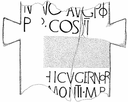
The remains of the Ingliston Milestone (Ingliston is on the western outskirts of Edinburgh) bear an inscription (RIB 2313, pictured leftabove) which evidently dates from the period 140 to 144 – being the time when Antoninus Pius was COS III (i.e. Consul 3 times). Two lines have been deliberately and neatly erased from the inscription, suggesting that they named someone – presumably the governor of Britain at the time the milestone was erected – who was subsequently disgraced, and was obliterated from official monuments. This certainly could not be Urbicus, but a person who could neatly fit the bill is one Cornelius Priscianus. As recorded by the Fasti Ostienses (a, fragmentary, inscribed-stone calendar/chronicle from Ostia), this individual was denounced by the senate on 15th September 145, for “hostile action disturbing the peace of the province of Spain”. And the Historia Augusta (‘Antoninus Pius’ 7) notes that: “Priscianus did indeed die for aspiring to the throne, but by his own hand”. It is generally accepted that, at the time of his downfall, Priscianus was governor of Hispania Tarraconensis (broadly, eastern and northern Spain and northern Portugal). The hypothesis that it was Priscianus who succeeded Urbicus as governor of Britain in 142 or early-143, and then transferred to Spain in 145, is attractive, though Anthony R. Birley* points to the difficulty of fitting Priscianus’ name and title into the space available on the milestone. In 146 the governor of Britain, named in a military diploma (RIB 2401.10), was Papirius Aelianus.
* The Roman Government of Britain (2005), pp.141–2.
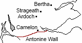
Outpost-forts north of the Antonine Wall were garrisoned – the sites of earlier forts at Camelon, less than a mile north of the Wall, and Ardoch, Strageath and Bertha, all three on the Gask Ridge, being reused. Hadrian’s Wall was, for the time being anyway, redundant – milecastle gates were removed and the Vallum was slighted (i.e. crossing places were made, by digging gaps in the mounds and using the earth to make a causeway across the ditch, at frequent intervals).
Hadrian’s Wall recommissioned
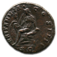
(•)A copper ‘as’ of Antoninus Pius, dated 155.[*] Britannia appears to be holding her hand to her forehead in sorrow.
It would appear that the Antonine Wall was ‘a bridge too far’ for the Romans. Coins of 155, showing a dejected looking Britannia, are suggestive of a recent military crisis in Britain – doubtless in the North.[*] There are indications that, in about 158, a phased withdrawal back to the Tyne-Solway line began. For instance, a now lost inscription, dated 158 (RIB 1389), evidently referred to rebuilding on Hadrian’s Wall itself, and the erstwhile outpost-fort at Birrens was rebuilt in the same year (RIB 2110). On the other hand, a coin dating to 164–9 suggests that the fort at Old Kilpatrick, the western terminus of the Antonine Wall, was, for the time being, still occupied.
wall08
The now lost inscription (RIB 1389) – the stone was found, apparently towards the eastern end of Hadrian’s Wall (Wall-mile 8 or 9), in 1751/2, at which time a drawing was made – records that “The 6th Legion Victrix Pia Fidelis rebuilt this in the consulship of Tertullus and Sacerdos”, i.e. in 158.
The original outpost-fort at Birrens (the furthest west of the outposts), built under Hadrian, had been demolished and rebuilt on a larger scale consequent to the Antonine reoccupation of southern Scotland. This fort was evidently destroyed by fire (not necessarily as the result of hostilities), and in 158 was rebuilt again. Presumably(?) these rebuilds represent the re-purposing of the fort from outpost-fort to hinterland-fort, and back to outpost-fort.
The lower right-hand corner of a dedication slab, no doubt from Birrens, was found in 1991, reused in a nearby Northumbrian monastic site, at Hoddom. The slab is dated by its decorations, which are stylistically similar to those on Antonine Wall distance slabs – in other words it relates to the rebuild carried out when southern Scotland was reoccupied. The inscription (RIB 3486) indicates that it was detachments of the 8th Legion Augusta and the 22nd Primigenia – evidently reinforcements drafted-in from Germania Superior (Upper Germany) to assist with the reconquest – who carried out the rebuild. Inscriptions on altars (RIB 2093, 2097, 3485) show that the fort was garrisoned by the 1st Nervan Cohort of Germans, ‘one thousand strong’ equitata. The final rebuild at Birrens, in 158 (when Antoninus Pius was in his 21st year of Tribunician Power), was carried out by the 2nd Cohort of Tungrians, ‘one thousand strong’ equitata – they, along with the governor at the time, Julius Verus, are named on a dedication slab found at Birrens in 1895 (RIB 2110). Several other inscriptions (RIB 2092, 2094, 2100, 2104, 2107, 2108, 2109, 2115) demonstrate that this same unit garrisoned the fort.
The latest coin excavated in a fort on the Antonine Wall is a denarius of Empress Lucilla, from the granary of the fort at Old Kilpatrick. Lucilla, the daughter of Marcus Aurelius, became Empress (i.e. she was granted the title Augusta) when she married her father’s co-emperor, Lucius Verus, in 164. Verus died in 169, at which point Lucilla was Empress no more.
Antoninus Pius died in 161. He was succeeded by, joint emperors, Marcus Aurelius and Lucius Verus.[*]
… war was threatening in Britain, and the Chatti had burst into Germany and Raetia. Against the Britons Calpurnius Agricola was sent; against the Chatti, Aufidius Victorinus.
Historia Augusta ‘Marcus Antoninus the Philosopher’ 8
Inscriptions naming Sextus Calpurnius Agricola testify to activity along the Tyne-Solway line during his tenure as governor. One, on a building dedication slab from Corbridge (RIB 1149), is dated 163.[*] Calpurnius Agricola’s tenure as governor of Britain probably ended c.166, and it seems likely that it was he who oversaw the final abandonment of the Antonine Wall and recommissioning of Hadrian’s Wall.
As well as refurbishment of the existing infrastructure, modifications were made to Hadrian’s Wall – the remaining turf section was probably rebuilt in stone at this time, and a road, the Military Way, constructed on the south side of the Wall (in places the road runs on top of the north mound of the Vallum).[*] As before, outpost-forts were garrisoned – forts at Birrens, Netherby and Bewcastle, in the west, were joined by others – at Risingham, High Rochester, Cappuck and Newstead – along the line of Dere Street, in the east.
D.J. Woolliscroft ‘Agricola: he came, he saw, but did he conquer?’ (2005), the Roman Gask Project website, freely available online.
Dacia: modern Romania (more or less).
Moesia: Roman province comprising parts of modern Bulgaria and Serbia. Southern neighbour, across the Danube, of Dacia.
There is an inscription (ILS 9193) which commemorates one Titus Cominius Severus, a centurion of the 2nd Adiutrix who was decorated in “the Dacian War” – this is Domitian’s Dacian war, since the emperor who made the award is anonymous, and, after his assassination in 96, the senate ordered that Domitian be wiped from public record (damnatio memoriae). Whilst it is possible that Cominius Severus was serving with a vexillation, i.e. a detachment of the legion, an inscription (ILS 2719) recording that the 2nd Adiutrix’s senior tribune was decorated by the vote of the legion’s other five tribunes in “the Suebian-Sarmatian War”, of 92, demonstrates that the whole legion had certainly reached Moesia by that time.
Moesia was divided into two provinces (Moesia Superior and Moesia Inferior) by Domitian c.86. Dacia was eventually annexed by Trajan in 106.
‘Excavations at the Roman Fort of Newstead, 1947’ by Prof. Ian A. Richmond:
Legionary swords and a helmet came from pit LVII, below the Baths, in association with first-century pottery. On the other hand, this pit also produced unmistakable auxiliaries’ equipment. Thus, if legionaries were in garrison at this epoch, they were not alone. The condition of the armour, moreover, was eloquent of disaster, and this corresponds to the evidence pointing to firing of the buildings, in the form of burnt wattle-and-daub.
Proceedings of the Society of Antiquaries of Scotland Vol. 84 (1949–50)
Julius Caesar described the Britons’ chariot tactics:
Chariots are used in action in the following way. First of all the charioteers drive all over the field, the warriors hurling missiles; and generally they throw the enemy’s ranks into confusion by the mere terror inspired by their horses and the clatter of the wheels. As soon as they have penetrated between the troops of [their own] cavalry, the warriors jump off the chariots and fight on foot. The drivers meanwhile gradually withdraw from the action, and range the cars in such a position that, if the warriors are hard pressed by the enemy’s numbers, they may easily get back to them. Thus they exhibit in action the mobility of cavalry combined with the steadiness of infantry; and they become so efficient from constant practice and training that they will drive their horses at full gallop, keeping them well in hand, down a steep incline, check and turn them in an instant, run along the pole, stand on the yoke, and step backwards again to the cars with the greatest nimbleness.
An inscription from Rome (ILS 2288) lists all the Empire’s legions in geographical sequence. Since two legions founded c.165, by Marcus Aurelius, are not in their proper positions, but tagged on the end (along with three legions created, in 197, by Septimius Severus), the list was probably originally compiled before 165. At any rate, the 9th is not included, so the inference must be that it was destroyed or disbanded by 165.
Diploma published in 1997: Johannes Nollé, with Addendum by Margaret M. Roxan, ‘Militärdiplom für einen in Britannien entlassenen ‘Daker’ ’, Zeitschrift für Papyrologie und Epigraphik 117, freely available online.
Roman miles. A Roman mile (i.e. mille passus – literally ‘a thousand paces’), at about 1,620 yards, is a little shorter than the standard mile of today (1,760 yards). 80 Roman miles equates to around 73 modern miles or 118 kilometres.
The Roman road known as Dere Street began in York, passed through Corbridge and crossed Hadrian’s Wall, a couple of miles to the north, at a substantial gateway (known as Portgate). Lollius Urbicus is named in inscriptions on two sandstone building dedication slabs from the fort at Corbridge (RIB 1147 and RIB 1148). Both buildings were constructed by the 2nd Legion. These dedication slabs had subsequently been reused as paving slabs in the two granaries whose remains are still visible. It is a reasonable assumption that the dedication slabs were from the earlier granaries. In RIB 1147, Antoninus is in his 2nd consulship, i.e. 139, in RIB 1148 he is in his 3rd, i.e. 140.
It seems to have been Michael G. Jarrett* who first argued the possibility that Karus won “his unique collection of decorations” at Mons Graupius.
* ‘Non-legionary Troops in Roman Britain: Part One, The Units’, Britannia Vol. 25 (1994).
The Asturians’ homeland was in north-western Spain.
Named after a passage in Julius Caesar’s Gallic War (VII, 73):
… arranged in slanting rows in the form of a quincunx, pits were dug, three feet deep, which tapered gradually towards the bottom. Smooth logs, as thick as a man’s thigh, sharpened at the top and hardened by fire, were planted in them, projecting not more than four fingers above the ground. At the same time the earth was trampled down to the depth of one foot above the bottom, to keep them firmly in position; while the rest of the pit was covered with twigs and brushwood to hide the trap. There were eight rows of this kind, three feet apart. The men called them ‘lilies’ (lilia), from their resemblance to that flower.
One of this eleven is at Inveravon, where there are certainly the remains of a military structure – in all likelihood, but not proven to be, a fort.
A fragment of an oak dedication-inscription, found at Turf Wall Milecastle 50, survives (RIB 1935). The name of Platorius Nepos can be restored, but insufficient remains to indicate the legion responsible for the construction.
The Cugerni were from the west bank of the Lower Rhine – around the modern German town of Xanten.
Trimontium is the Roman fort at Newstead (near Melrose), on Dere Street.
When Hadrian adopted Antoninus Pius as his son and heir, in 138, he made it a condition that Antoninus should adopt 16 year-old Marcus Aurelius and 7 year-old Lucius Verus – the latter being the son of Hadrian’s first choice of heir, the lately deceased, Lucius Aelius. Marcus Aurelius was groomed to be Antoninus’ successor, and duly became emperor, in 161, when Antoninus died. Marcus Aurelius (noted for his Stoic philosophy, and also known as Marcus Antoninus), however, insisted on sharing power equally with his adoptive brother, Lucius Verus. They ruled as co-emperors until Verus’ death in 169.
With the passing of time, confusion arose concerning the origins of both Hadrian’s Wall and the Antonine Wall. It is, perhaps, remarkable that the wall now known to be Hadrian’s Wall was not positively identified until the 19th century. See The Wall of Severus.
The fort at Cappuck (the 4th on the site) was very small – internally, some 210 by 240 feet (an area of just over an acre).
Some forts straddle the line of Hadrian’s Wall. At these sites, e.g. Halton Chesters, about one third of the fort projects north of the Wall itself.
The marble commemorative slab from a building at Caerleon is dated 100 (RIB 330). A stone commemorative slab, apparently from a gate at York, is dated 108 (RIB 665). A couple of fragments of a slate commemorative slab, apparently from a gate at Chester, if the inscription has been correctly restored, date to between 102 and 117 (RIB 464).
The pictured coin is in the possession of the British Museum.
Hadrian’s titles arc around the depiction of Britannia [going off the flan]:
PONT MAX [TR POT] COS III
i.e. Pontifex Maximus (High Priest) Tribunicia Potestas (holding Tribunician Power) Consul III (Consul 3 times)
Hadrian became consul for the 3rd, and last, time in 119. In 128 he accepted the title Pater Patriae, i.e. Father of his Country, and this is not indicated on the coin, so it must date between 119 and 128. Stylistically, however, these coins (the example pictured is of type RIC II 577b; type 577a is slightly different) are placed at the very beginning of this period.
(The legend S C – Senatus Consulto, i.e. ‘by Decree of the Senate’ – is generally found on the reverse of the Empire’s base-metal issues until the mid-3rd century.)
The pits are thought to be the visible remains of obstacles similar to a type that Julius Caesar referred to as cippi, in his description of the siegeworks he employed at Alésia in 52 BC:
… trees or very stout branches were cut down and their ends stripped of their bark and sharpened to a point; continuous trenches were then dug, five feet deep, in which the logs were planted and fastened down at the bottom to prevent their being dragged out, while the boughs projected above. There were five rows in each trench, connected with one another and interlaced; and all who stepped in would impale themselves on the sharp stakes. The men called them ‘gravestones’ (cippi).
The Gallic War VII, 73
Hadrian’s Wall Archaeological Research by English Heritage 1976–2000, edited by Tony Wilmott (2009), freely available online, in which the likelihood that the marginal mound was a primary feature, i.e. part of the original concept, of the vallum is suggested. Though in ‘Excavations at Vallum Causeways on Hadrian’s Wall in the 1950s’, Archaeologia Aeliana Series 5, Vol. 37 (2008), freely available online, Brenda Heywood and David J. Breeze conclude that the marginal mound is a later feature.
The notion, popularized by Rosemary Sutcliff in The Eagle of the Ninth (1954), that, at the beginning of Hadrian’s reign, the 9th Legion “marched north to deal with a rising among the Caledonian tribes, and was never heard of again” does not hold water. There are inscriptions recording the careers of men who were officers in the 9th that require the legion’s existence in the 120s, and possibly as late as 140.[*] There is evidence (a stamped tile and a stamped bowl) from Nijmegen (now in the Netherlands, then in Germania Inferior), which cannot be dated with any precision, to place the 9th there at some stage. Cassius Dio (in the abridgement of Xiphilinus) reports:
… all Judaea had been stirred up, and the Jews everywhere were showing signs of disturbance … Hadrian sent against them his best generals. First of these was Julius Severus, who was dispatched from Britain [in c.133], where he was governor [could he have taken the 9th with him?] … nearly the whole of Judaea was made desolate … Many Romans, moreover, perished in this war.
Roman History LXIX, 13–14
The date 140 is arrived at by accepting that the Numisius Junior, who early in his career (listed in CIL XI, 5670) served as a tribune in the 9th Legion, is the same Numisius Junior who was consul in 161.
Antoninus Pius is ‘Imperator II’ in a military diploma dated 1st August 142 (L’ Année épigraphique 1995, 1824).
On the obverse of this coin (type RIC III 745) Antoninus Pius is COS III, i.e. ‘Consul 3 times’, which is the period 140–144. A military diploma (L’ Année épigraphique 1995, 1824) indicates that he became IMPERATOR II in the summer of 142.
There seems to be a scholarly reluctance to dismiss the garbled statement of Pausanias regarding the Brigantes’ invasion of the mysterious “Genounia”, and it is commonly suggested that he is referring to a rebellion amongst the Brigantes at this time – the coin issue, therefore, celebrating the successful put-down of the revolt. Pausanias, though, was listing highlights of Antoninus’ rule, so why would he choose to mention this supposed rebellion of the Brigantes, rather than Antoninus’ major military achievement, i.e. conquering southern Scotland and building the Antonine Wall?
This coin (type RIC III 934) is dated to 155 by the inscription TR P XVIII (on the obverse, adjacent to the chin), i.e. Antoninus was in the 18th year of Tribunician Power. (To be precise, according to Harold Mattingly*, Antoninus’ 18th year would have been from 10th December 154 to 9th December 155.) The pictured example is in the Kunsthistorisches Museum Wien.
* Coins of the Roman Empire in the British Museum Vol. 4 (1940), ‘II. Special Introduction to Reigns’.
There are two inscriptions naming Calpurnius Agricola from Corbridge. One (RIB 1149) survives only as a few fragments of a large dedication slab, but the inscription can be restored to show that it was from a building constructed by the 20th Legion in 163. The other (RIB 1137) is from a temple of “the Unconquered Sun-god” constructed by the 6th Legion. There is a fragment of a dedication slab from Vindolanda – only Calpurnius Agricola’s name can be restored (RIB 1703). There are two inscriptions from Carvoran, both on altars. One (RIB 1792) honouring “the Syrian Goddess”, set up by one Licinius Clemens, prefect of the 1st Cohort of Hamians (a unit of archers originating in Syria). The other (RIB 1809) is less complete – it too was set up by the prefect Licinius Clemens, but neither the deity nor his unit are extant. There is also an inscription (on two fragments of a dedication slab that are now lost) from Ribchester, further south, in Lancashire, that names Calpurnius Agricola (RIB 589).
The translation of the Historia Augusta used in this webpage (the well-known, widely available, Loeb Classical Library edition, first published 1921), actually renders the highlighted phrase: “and built a second wall, one of turf”. The Latin (alio muro caespiticio ducto), however, is certainly not that unequivocal. Indeed, the phrase: “another wall, of turf, being set up” (given by Anthony Birley, in his translation, under the title Lives of the Later Caesars, 1976) may be a step too far, since it still indicates that the earlier wall being referred to was not of turf. It might be that the reading should be: “another wall of turf being set up”.

 (•)
(•)
 Excavations of the berm (the ledge between wall and ditch), at places along the easternmost section (roughly a dozen miles) of the Wall, have, since 2000, uncovered rows of pits. It is thought that they held obstacles – branched, sharpened stakes – acting like barbed wire would today.[*]
 The Vallum comprises a steep-sided, flat-bottomed, ditch, some 9 feet deep and 20 feet wide – there were crossing points (gated causeways) associated with the Wall forts – with a 20 foot wide mound around 30 feet distant on either side. (For much of its length, there is a third mound, the so called ‘marginal mound’, on the southern edge of the ditch. It seems to be a design feature, rather than the result of ditch cleaning-out operations, but it may be a later development.[*]) Where topography allows, the Vallum runs close to the Wall, and in these sections it loops around the Wall forts – hence the Vallum cannot predate the forts. The fort at Carvoran was one of the earlier Stanegate forts, kept on for service as a Wall fort. Consequently, it is detached, by some 240 yards from the Wall. Here, the Vallum runs between fort and Wall. At Castlesteads, however, where the fort is 140 yards further from the Wall (it is not known whether this fort has pre-Hadrianic origins), the Vallum diverts to encompass it. At any rate, elsewhere, such as in the central section where the Wall sits atop Whin Sill, the Vallum runs in long straight stretches on the nearest feasible line. At its greatest distance, it is around ½ mile from the Wall. It is generally supposed that the Vallum’s purpose was to create a secure zone behind the Wall.
 (•)
(•)
 (•)
(•)